White Traun
| White Traun | ||
|
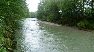
The White Traun near Siegsdorf |
||
| Data | ||
| Water code | EN : 1848 | |
| location |
Bavaria
|
|
| River system | Danube | |
| Drain over | Traun → Alz → Inn → Danube → Black Sea | |
| origin | Confluence of Seetraun and Fischbach 47 ° 43 ′ 37 ″ N , 12 ° 39 ′ 36 ″ E |
|
| Source height | approx. 690 m above sea level NN | |
| confluence | with the Roten Traun to the Traun Coordinates: 47 ° 49 ′ 58 ″ N , 12 ° 38 ′ 46 ″ E 47 ° 49 ′ 58 ″ N , 12 ° 38 ′ 46 ″ E |
|
| Mouth height | approx. 600 m above sea level NN | |
| Height difference | approx. 90 m | |
| Bottom slope | approx. 6.8 ‰ | |
| length | 13.3 km | |
| Discharge at the Siegsdorf A Eo gauge : 182 km² Location: 800 m above the mouth |
NNQ (10.10.1947) MNQ 1926–2006 MQ 1926–2006 Mq 1926–2006 MHQ 1926–2006 HHQ (12.08.2002) |
910 l / s 2.19 m³ / s 7.77 m³ / s 42.7 l / (s km²) 99.3 m³ / s 248 m³ / s |
|
Confluence of the Roter (back left) and Weißer Traun (back right) to the Traun |
||
The White Traun is the left source river of the Traun in Upper Bavaria .
geography
Spring streams
Fischbach
The watercourse with the river code number 1848 begins at the source of the Fischbach , which on Austrian territory 2 km east of the Winklmoos-Alm approx. 1180 m above sea level. NN is ( 47 ° 39 ′ 17 ″ N , 12 ° 36 ′ 44 ″ E ). After a flow distance of 12.34 km it forms the White Traun together with the Seetraun in the Ruhpolding district of Laubau .
Sea brown
The Seetraun carries this name from the union of the Rammelbach , which is known as the Ostertalgraben on the northern slope of the Seehauser Kienberg at 47 ° 42 '25 " N , 12 ° 35' 37" E at about 1300 m above sea level. NN rises with the outflow of the Förchensee a good 300 meters below the Förchensee outflow to Laubau and is managed under the DGWK 184812.
course
The White Traun is created by the confluence of the Fischbach and Seetraun in Laubau . It flows in a northerly direction through Ruhpolding and Siegsdorf and crosses under the A8 before it joins the Roten Traun to form the Traun after 13.31 km .
Tributaries
- Fischbach (right upper course)
- Seetraun (left upper course)
- Windbach (right)
- Urschlauer Achen (left)
- Wiedmoosgraben (right)
- Steinbach (left)
- Tiefenbach (left)
- Edergraben (right)
- Dießelbach (left)
- Nattergraben (right)
- Reinerbach (right)
- Habachgraben (left)
- Spatzreiter Graben (right)
- Schönecker Graben (right)
Web links
Individual evidence
- ↑ a b Google Earth
- ↑ a b GeoFachDatenAtlas and water services of the Bavarian State Office for the Environment
- ^ German Hydrological Yearbook Danube Region 2006 Bavarian State Office for the Environment, p. 250, accessed on October 4, 2017, from: bestellen.bayern.de (PDF, German, 24.2 MB).

