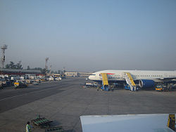
Benazir Bhutto International Airport
| Benazir Bhutto International Airport | |
|---|---|

|
|
| Characteristics | |
| ICAO code | OPRN |
| IATA code | ISB |
| Coordinates | |
| Height above MSL | 508 m (1667 ft ) |
| Basic data | |
| Passengers | 4,767,860 (2015/16) |
| Air freight | 53,020 t (2015/16) |
| Flight movements |
39,676 (2015/16) |
| Start-and runway | |
| 12/30 | 3287 m × 46 m asphalt |
The Benazir Bhutto airport , even Islamabad Airport ( english : Benazir Bhutto Airport , including Islamabad International Airport or Chaklala Airport ) is the second largest airport of Pakistan . It has been named after the former Prime Minister of Pakistan and opposition leader Benazir Bhutto, who was killed in an attack in 2008 .
Location and directions
The airport is located eight km south-southwest of the city of Islamabad and three km east of Rawalpindi . One of the ways to get to the airport by car is via the Islamabad Highway.
The tower (TWR) sends and receives on the frequency : 123.7 MHz . The airport has various navigation aids. The runway 12/30 has an instrument landing system (ILS). The non-directional radio beacon (NDB) transmits on the frequency: 344 kHz with the identifier: RN. The rotating radio beacon (VOR) transmits on frequency : 112.1 MHz with the identifier: RN. A distance measuring equipment (DME) is present.
Incidents
- On July 28, 2010, all 152 people on board an Airbus A321 operated by Airblue ( aircraft registration AP-BJB ) died while approaching Islamabad. The Airbus, coming from Karachi Airport , was flown 14 km northwest of Benazir Bhutto Airport into the Margalla Hills . The cause was the captain flying a "self-made" approach procedure below the minimum height. He did not react to any information from the First Officer or to a total of 21 warnings from the EGPWS ground warning device (see also Airblue flight 202 ) .
- On April 20, 2012, all 127 people on board a Boeing 737-200 of the airline Bhoja Air ( AP-BKC ) died while approaching Islamabad. The Boeing, coming from Karachi Airport, flew into the ground four km from the airport on its final approach to runway 30 during a thunderstorm with almost no reaction from the pilots and broke (see also Bhoja Air flight 213 ) .
See also
Web links
- Airport data in the Aviation Safety Network (English)
- Airport data. In: flightstats.com. Retrieved August 20, 2010 .
- Airport data on World Aero Data ( 2006 )
- Airport data. In: The Airport Guide. Retrieved August 20, 2010 .
Individual evidence
- ↑ a b c Major Traffic Flows By Airports During The Year July 2015 / June 2016. (PDF) In: caapakistan.com.pk. Pakistan Civil Aviation Authority, accessed March 15, 2018 .
- ↑ Airport data on World Aero Data ( English, as of 2006 )
- ^ Accident report A321 AP-BJB , Aviation Safety Network (English), accessed on December 8, 2016.
- ^ Accident report B-737-200 AP-BKC , Aviation Safety Network (English), accessed on December 8, 2016.