
Fordingbridge
| Fordingbridge | |||
|---|---|---|---|
 |
|||
| Coordinates | 50 ° 56 ′ N , 1 ° 47 ′ W | ||
|
|||
| Residents | 5998 | ||
| administration | |||
| Post town | Fordingbridge | ||
| ZIP code section | SP6 | ||
| prefix | 01425 | ||
| Part of the country | England | ||
| region | South East England | ||
| Shire county | Hampshire | ||
| District | New Forest | ||
| Website: Fordingbridge | |||

Fordingbridge is a town and larger civil parish with about 6000 inhabitants in the New Forest district in the county of Hampshire in the south of England on the Avon . The name Fordingbridge indicates that a bridge was built in the place of a ford. The hamlets of Brookheath , Tinker's Cross and East Mills belong to the place .
location
Fordingbridge is located about 150 kilometers (driving distance) southwest of London on the western edge of the former royal hunting ground and today's New Forest National Park . It is located in the middle of an imaginary triangle between the cities of Southampton , Salisbury and Bournemouth . The A338 road runs from Bournemouth through Fordingbridge to Salisbury.
history
In the Domesday Book of 1085/1086 the place is mentioned as Forde . A first bridge is said to have been built before 1272. For this year, pontoons were brought into place for bridge repairs. The remaining bridge consists of seven stone arches. It gave the place a certain importance. From the 16th century textiles were produced in Fordingbridge.
Attractions
- The parish church of St Mary's, originally from the 12th century, almost entirely rebuilt from 1220 to 1240, tower from the 15th century
- Stone bridge
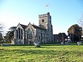
Marienkirche

Stone bridge
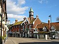
town hall


Personalities
- Augustus John (1878–1961), Welsh painter, died here
- Albert Gladstone (1886–1967), rower, died here
- Terence Frederick Mitchell (1919–2007), linguist, died here
- Neil McCarthy (1932–1985), actor, died here
- David Oakes (* 1983), actor, grew up here
Town twinning
There is a partnership with the French municipality of Vimoutiers .
Trivia
A plaque at St Mary's Church commemorates James Alexander Seton, who was the last Briton to be killed in a duel in 1845.