
Fourges
| Fourges | ||
|---|---|---|
|
||
| local community | Vexin-sur-Epte | |
| region | Normandy | |
| Department | Your | |
| Arrondissement | Les Andelys | |
| Coordinates | 49 ° 7 ' N , 1 ° 38' E | |
| Post Code | 27630 | |
| Former INSEE code | 27262 | |
| Incorporation | January 1, 2016 | |
| status | Commune déléguée | |

Fourges is a village and a former French community with 770 inhabitants (as of January 1 2017) in the Eure in the region of Normandy . It belonged to the Arrondissement of Les Andelys and the Canton of Les Andelys .
With effect from January 1, 2016, the previously independent municipalities of Berthenonville , Bus-Saint-Rémy , Cahaignes , Cantiers , Civières , Dampsmesnil , Écos , Fontenay-en-Vexin , Forêt-la-Folie , Fourges , Fours-en-Vexin became , Guitry , Panilleuse and Tourny have merged to form a nouvelle commune with the name Vexin-sur-Epte and have the status of a déléguée commune in the new commune . The administrative headquarters are located in Écos.
location
Fourges is affected by the Epte river . Neighboring towns are Heubécourt-Haricourt and Écos in the west, Bus-Saint-Rémy in the north, Bray-et-Lû in the northeast, Amenucourt in the east and Gasny in the south.
Population development
| year | 1962 | 1968 | 1975 | 1982 | 1990 | 1999 | 2008 | 2015 |
|---|---|---|---|---|---|---|---|---|
| Residents | 312 | 321 | 419 | 453 | 685 | 772 | 816 | 799 |
Attractions
- Castle of Fourges
- Military cemetery
- Watermill on the Epte
- Saint-Pierre church, designated as a monument historique since 1962

Castle of Fourges

Military cemetery

Watermill
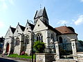
Saint-Pierre church


