
Berthenonville
| Berthenonville | ||
|---|---|---|

|
|
|
| local community | Vexin-sur-Epte | |
| region | Normandy | |
| Department | Your | |
| Arrondissement | Les Andelys | |
| Coordinates | 49 ° 11 ′ N , 1 ° 40 ′ E | |
| Post Code | 27630 | |
| Former INSEE code | 27060 | |
| Incorporation | January 1, 2016 | |
| status | Commune déléguée | |
,_mairie,_rue_de_l%27%C3%89glise.jpg) former Mairie of Berthenonville |
||

Berthenonville is a village and a former French community with 249 inhabitants (as of January 1 2017) in the Eure in the region of Normandy . It belonged to the Arrondissement of Les Andelys and the Canton of Les Andelys .
With effect from January 1, 2016, the previously independent municipalities of Berthenonville , Bus-Saint-Rémy , Cahaignes , Cantiers , Civières , Dampsmesnil , Écos , Fontenay-en-Vexin , Forêt-la-Folie , Fourges , Fours-en-Vexin became , Guitry , Panilleuse and Tourny have merged to form a nouvelle commune with the name Vexin-sur-Epte and have the status of a déléguée commune in the new commune . The administrative headquarters are located in Écos.
location
Neighboring towns are Cahaignes in the north-west, Château-sur-Epte in the north, Saint-Clair-sur-Epte in the north-east, Montreuil-sur-Epte in the south-east, Dampsmesnil in the south, Écos in the south-west and Fours-en-Vexin in the west.
Population development
| year | 1962 | 1968 | 1975 | 1982 | 1990 | 1999 | 2008 | 2015 |
|---|---|---|---|---|---|---|---|---|
| Residents | 181 | 146 | 153 | 158 | 177 | 211 | 233 | 254 |
Attractions
- Berthenonville Castle
- Saint-Ouen church, designated as a historic monument since 1926
- War memorial
- Floor cross

Berthenonville Castle

Saint-Ouen church

War memorial on the village square
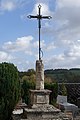
Floor cross
,_ch%C3%A2teau_de_Berthenonville,_RD_146.jpg)

,_monument_aux_morts,_place_du_village_02.jpg)
