Frenswegen
|
Frenswegen
City of Nordhorn
Coordinates: 52 ° 27 ′ 17 ″ N , 7 ° 2 ′ 15 ″ E
|
||
|---|---|---|
| Height : | 21 m above sea level NN | |
| Area : | 2.86 km² | |
| Residents : | 43 (Dec. 31, 2013) | |
| Population density : | 15 inhabitants / km² | |
| Incorporation : | April 1, 1929 | |
| Postal code : | 48527 | |
| Area code : | 05921 | |
|
Location of Frenswegen in Lower Saxony |
||
|
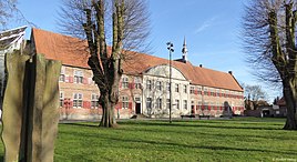
Main view Frenswegen Monastery Foundation
|
||
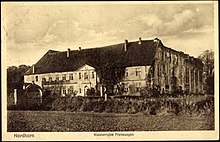
To the northwest of the city of Nordhorn , about four kilometers away, is the district of Frenswegen . A place whose residents, who used to be mainly active in agriculture, are closely linked to the economic ups and downs of the Frenswegen Monastery here .
location
The area of this former Hovesaat (Hofesaat) Frenswegen, around 152 hectares in size, lies on a peninsula-like sand ridge, ideally situated, bordered by the Vechte valley and the lowlands of the Frensdorfer Bruch. The old traffic routes lay along the river, the river offered fishing, its floodplains provided pasture and food for cattle breeding. The hinterland with today's forests served as an important reservoir of raw materials and as a pasture area for herds of sheep, with heather and moor areas.
Surname
The current name Frenswegen developed over the course of history from names such as Frendeswege, Vrendeswege, Vrendesweel, Vredeswege and Vrendeswice. Since this Hovesaat is located on the main path of the Frensdorf farmers, the name can be derived from the location of Frens and ways .
history
The earliest traces of human presence in Frenswegen date from the time around the birth of Christ. In 1938, traces of the Iron Age were discovered during cultivation work on the “Uhlenbölt”, west of the Paradiesweg behind today's natural gas station. Excavations revealed the floor plan of a three-aisled hall house. For a long time, a nearby meadow was named "Kerkhoff" (cemetery) by long-established farmers from Frenswegen. This name suggests a cremation graveyard from the Iron Age.
Concrete traces of rural life in and around Frenswegen are lost in the following years. Field names, topographical findings and scarce written documents were evaluated and it can be regarded as certain that when the Frenswegen Monastery was founded in 1394 there were six farms in Frenswegen.
The following names are recorded: Eynoldingh, Albertink, Hinrikink, Vuust, Horst or "Stevenshusis" and Gherdes. Count Bernhard I von Bentheim left the Eynoldingh heritage to the founders of the monastery . At the same time or a short time later the monastery founders were given two more farms. It is said to have been the Hinrikink and Albertink farms.
The other existing courtyards have all subsequently come into the possession of the monastery. At that time they must have been orphaned or inhabited by peasants with no descendants, as it is difficult to imagine that they were lowered to the status of hirers , as was later applied in the area of the Hovesaat residents.
The monastery quickly gained in reputation and was affiliated to the Windesheim congregation as early as 1400 . This means that there is brisk construction activity on the monastery building. The prior acquired pastureland for flocks of sheep in the surrounding area and through generous donations from Count Bernhard I of Bentheim and other benefactors, the convent received many lands and land. In the years 1396–1498, the monastery owned around 80 farmer heirs in eleven parishes and the neighboring Netherlands. All farmers were self-employed in the monastery.

A downturn began in 1544 with the Reformation and the change of the Count from Bentheim to the Lutheran denomination. In 1560 the count forbade the convent to accept new novices and after the beginning of the Eighty Years' War in the neighboring Netherlands, the canons left Frenswegen in 1580 to move to the city castle in Nordhorn. They bought these from Count Arnold II von Bentheim in 1578. With the departure, the buildings began to decline.
The renovation of the monastery and the reconstruction of the abandoned and partially collapsed farm buildings did not begin until 1641, and in 1655 the convent returned to the monastery building. Until it was abolished in 1809, the monastery experienced a second heyday because Count Ernst Wilhelm von Bentheim converted to Catholicism in 1668.
In the following years a lot changed on the Hovesaat and the monastery building. Many construction works were carried out. Various ornamental and kitchen gardens were laid out around the large monastery building with an inner courtyard, and oak avenues were planted, in particular the avenue that tapers on the western front of the monastery, today's Fuchsweg, and the avenue that leads from the forecourt to the old inn on the main street .
The monastery building was protected by a defensive ring with fences, gates and moats.
Various farm buildings, some of which are still standing today, were built on the Hovesaat, such as a monastery bakery, a hospital (later used as a small pub), two granaries and, further away on the border of the Hovesaat, called Neustadt, three buildings that were probably called Sheeppens of the monastery were used. Two buildings were built on today's Kohlandweg, near the granary. They served as a grain and oil mill and were powered by Vechtewasser, which flowed through a moat between the houses. These graves were fed by water derived from the Vechte and also had a connection to the protective moats of the monastery.
The main agricultural areas were to the south of the monastery, the Maaten, a grassland used for grass and hay extraction, and to the west, the high arable land, consisting of Schlat , Esch and Albertink , mainly used for rye cultivation.
With the beginning of the French wars, France also took possession of the county of Bentheim. In 1804, Count Ludwig zu Bentheim was able to redeem his land from French ownership and thus also took control of the monastery. At this time there were 17 wage dwellings in the Hovesaat and 96 adults and 35 children lived outside the monastery walls, mainly hunters who tilled the monastery grounds, as well as craftsmen and a landlord.
After the county of Bentheim was added to the Grand Duchy of Berg in 1806, the monastery and all wage apartments were placed under the Landdrosten von Elverfeldt. The decline was sealed in 1803 by the Reichsdeputationshauptschluss . It was officially repealed on October 25, 1809 by the government of the Grand Duchy of Berg. In 1815, Gerhard Többe, the last canon, left Frenswegen Abbey.
In a comparison with the Hanoverian government, which got the county back after the end of the Napoleonic wars, in 1823 the Prince of Bentheim and Steinfurt received the vacant monastery building as well as all buildings of the Hovesaat with an area of around 131 hectares and the hunting and fishing rights.
A rent master appointed by the prince , who himself lived in the monastery building, kept records of income and expenses and monitored compliance with the lease agreements that the princely domain chamber in Burgsteinfurt concluded with the hirers and tenants.
Molten iron
In the spring of 1824, Johann Hund, foreman of an ironworks near Bocholt, tried to convince Prince Alexis of Bentheim and Steinfurt of his plan to mine lawn iron ore and found an iron smelter in the monastery walls. Plans and costs for the damming of the required Vechtewater brought the plan down.
school
On March 18, 1827, 22 hiring workers applied to the Royal-British-Hanoverian government in Bentheim to set up a school in the monastery building and for an allowance for the maintenance of a teacher. The currently 40 school-age children from five to 14 years of age should be taught here again, as was done by an organist during the heyday of the monastery. The way to school in Nordhorn or to the Bookholt farmers is long, the crossing of the Vechte is dangerous, the school fees are high and the children are taught there in a reformed school. But it was not until the end of 1834, after years of slow planning, that lessons began in a prepared chamber of the Jüffernhaus on the monastery grounds. Much later, 36 years after the first application, in 1863, this provisional school operation was replaced with the construction of a new Catholic elementary school. The students from Frenswegen then attended this school for many generations.
In the years 1870–1871, around 600 French prisoners of war were housed in the monastery building in Frenswegen. Seven deceased French are buried in the cemetery next to the building.
The name of the manor district with the community leader Berning, which has now been achieved , was recognized as a local community by the Landdrostei Osnabrück in October 1849 . In the following, Hermann Schulten, district forester Jungemann and forest overseer Lichte are named as mayor. On April 1, 1929 the manor district of Frenswegen lost its independence by decision of the Prussian State Ministry and was incorporated into the city of Nordhorn.
Frenswegen today
In Frenswegen today only three farmers practice arable and livestock farming. Not many of the former houses have survived in their origins. Only two buildings described below should be mentioned. Besides the oil mill, other buildings were demolished or destroyed by fire. The existing buildings have been rebuilt according to the needs of the residents and only partially show traces of the past.
Monastery tavern
The earliest secure reference to an inn dates back to 1673. In this building, which was still used for centuries as a restaurant and is now empty, for operation of the Heuermann the monastery, Gerhardus Transs called Trans Gerdt , in addition to agriculture an inn. Here beer and schnapps were probably served to carters who drove their freight between Neuenhaus and Nordhorn and passed the monastery here.
In the period that followed, around 20 innkeepers worked here, including three generations of Tranß, Segelfort-Quaink, Berning, Deiting, Abel, Odinga, Göttker, Kischke, Müller, Pikkemaat and sub-tenants of the Rolinck brewery. The house was used for gastronomy for over 300 years. The frequent change of tenants has made the traditional name "Trans", under which the tenants were known for a long time and more than their house name, disappear.
The age of the current building cannot be precisely determined. It will probably only have been built as part of the baroque renovations. The building has belonged to the Frenswegen Monastery Foundation since 2000.
Dulinks Hus (house)
If you walk from the main portal of the monastery through the avenue for about 400 meters, you get to a part of Frenswegen called Neustadt . Of the old rural buildings on this path, Dulinks Hus is the only house in Frenswegen that has preserved the structure of the wooden frame with tapped anchor beams. According to research by local researchers, it is one of three buildings that initially served the monastery as sheep pens. Probably not built before 1780.
Generations of the Dulink (Duling) family, verifiably resident in Frenswegen since around 1700, tenant of the grain mill from 1809 to 1821; temporarily living in a chamber in the monastery; lived in this house from 1851 to 1972 and ran the farm here as self-employed or tenant.
literature
- Heinrich Voort: Contributions to the history of the Frenswegen monastery
- Burghard Sauermost: The Augustinian Canons Monastery Sankt Marienwolde
- Various local literature and articles as well as own research.


