Gülpınar (Ayvacık)
| Gülpınar | ||||
|
||||
| Basic data | ||||
|---|---|---|---|---|
| Province (il) : | Çanakkale | |||
| District ( ilçe ) : | Ayvacık | |||
| Coordinates : | 39 ° 32 ' N , 26 ° 7' E | |||
| Height : | 136 m | |||
| Residents : | 1,344 (2018) | |||
| Telephone code : | (+90) 286 | |||
| Postal code : | 17 862 | |||
| License plate : | 17th | |||
| Structure and administration (as of 2013) | ||||
| Muhtar : | Recep Şahin ( AKP ) | |||
Gülpınar is a village ( Köy ), and was previously the capital of a Bucak as a municipality in the Ayvacık district of the Turkish province of Çanakkale . At the end of 2018 it was the largest village in the district.
The place is in the west of the district, about 2.5 kilometers east of the Aegean coast, on the road that branches off from the E-87 at Ayvacık to the west and in an arc along the coast via Behramkale , Gülpınar and Geyikli in the north Europastraße leads back.
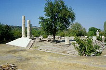
Gülpınar is located on the site of the ancient place Chryse , in the place are the remains of a temple of Apollon Smintheus . About 7.5 kilometers to the southwest lies Cape Baba ( Bababurun in Turkish ), which marks the westernmost point of the Asian mainland, with the place Babakale .
Individual evidence
- ↑ Türkiye Nüfusu İl ilçe Mahalle Köy Nüfusları , accessed on June 1, 2019


