
Gandhinagar (District)
| Gandhinagar District | |
|---|---|

|
|
| State | Gujarat |
| Administrative headquarters : | Gandhinagar |
| Area : | 2,140 km² |
| Residents : | 1,391,753 (2011) |
| Population density : | 650 inhabitants / km² |
| Website : | [1] District website |
The district of Gandhinagar ( Gujarati : ગાંધીનગર જિલ્લો ) is one of 26 districts of the state of Gujarat in India . The city of the same name Gandhinagar is the capital of the district. The last census in 2011 showed a total population of 1,391,753 people.
history
From pre-Christian times until 1298, the area - like the entire region - was ruled by various Buddhist and Hindu rulers. The first civilization was the Indus culture . The first state known by name was the Maurya Empire , the last non-Muslim dynasty were the Solanki . After centuries of military conflict with Muslim conquerors and rulers in northern India, it was occupied by Muslim soldiers in 1298. Thereafter, various Muslim dynasties ( Sultanate of Delhi , Sultanate of Gujarat and the Mughals ) ruled until 1753 . In 1753 the area became part of the Hindu Marathon Empire . Between 1802 and 1818 all regions of what is now the district came under British rule. The district became part of the Northern Division of the British administrative region of Bombay Presidency . With India's independence in 1947 and the reorganization of the country, it became part of the new state of Bombay in 1950 . In 1960 this Indian state was divided and the area came to the newly created state of Gujarat. Some areas of Ahmedabad District were separated in 1964 and formed part of the new Gandhinagar District. Further areas were spun off from the Mehsana district , thus completing the scope of the new Gandhinagar district.
population
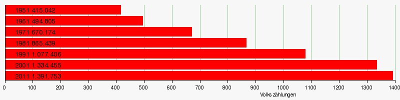
Population development
As everywhere in India, the population in the Gandhinagar district has been growing rapidly for decades. However, the increase slowed in the years 2001–2011 to around 4 percent (4.29%). In these ten years the population only increased by around 57,000 people. The following table shows the exact numbers:
Significant places

The most populous place in the district is the main town Gandhinagar with over 200,000 inhabitants. Other major cities with a population of more than 20,000 people are Kalol , Dehgam , Mansa and Pethapur . The urban population makes up 43.16 percent of the total population.

Web links
- Map of the Gandhinagar District
- Gandhinagar District
- Economy, nature and sights
- 2001 census result for Gandhinagar
- Gandhinagar District Statistical Handbook
Individual evidence
- ↑ 2011 census
- ^ History of the district up to 1900 in the Imperial Gazeteer Of India
- ^ Result of the 2011 census on city population
Coordinates: 23 ° 13 ' N , 72 ° 41' E

Ahmedabad | Amreli | Anand | Aravalli | Banaskantha | Bharuch | Bhavnagar | Botad | Chhota Udaipur | Dahod | Dang | Devbhoomi Dwarka | Gandhinagar | Gir Somnath | Jamnagar | Junagadh | Kachchh | Kheda | Mahisagar | Mehsana | Morbi | Narmada | Navsari | Panchmahal | Patan | Porbandar | Rajkot | Sabarkantha | Surat | Surendranagar | Tapi | Vadodara | Valsad