Gane
|
Gane Dozanne |
||
|
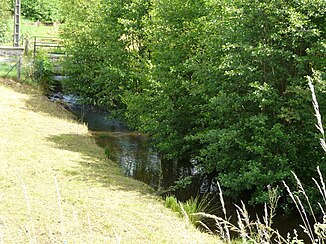
The river at Saint-Fréjoux |
||
| Data | ||
| Water code | FR : P0760500 | |
| location | France , Nouvelle-Aquitaine region | |
| River system | Dordogne | |
| Drain over | Diège → Dordogne → Atlantic Ocean | |
| source | in the municipality of Aix 43 ° 25 ′ 12 ″ N , 0 ° 14 ′ 22 ″ E |
|
| Source height | approx. 739 m | |
| muzzle | in the municipality of Saint-Victour in the Diège coordinates: 45 ° 27 ′ 21 ″ N , 2 ° 21 ′ 38 ″ E 45 ° 27 ′ 21 ″ N , 2 ° 21 ′ 38 ″ E |
|
| Mouth height | approx. 542 m | |
| Height difference | approx. 197 m | |
| Bottom slope | approx. 10 ‰ | |
| length | approx. 19 km | |
The Gane (in the upper reaches Dozanne called) is a river in France , who in the Correze in the region Nouvelle-Aquitaine runs. It rises in the Millevaches en Limousin Regional Nature Park , in the municipality of Aix from several source streams and initially drains under the name Dozanne in a generally southern direction. Below Veyrières is it with its definitive name Gane called and ends after a total of about 19 kilometers in the municipality of Saint-Victour in the backwater of the dam Barrage des Chaumettes as a left tributary to the Diège .
Places on the river
(Order in flow direction)
