Garlogy
| Garlogy | ||
|---|---|---|
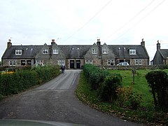
| Building in garlogie | ||
| Coordinates | 57 ° 8 ′ N , 2 ° 21 ′ W | |
|
|
||
| administration | ||
| Post town | WESTHILL | |
| ZIP code section | AB32 | |
| prefix | 01224 | |
| Part of the country | Scotland | |
| Council area | Aberdeenshire | |
| British Parliament | West Aberdeenshire and Kincardine | |
| Scottish Parliament | Aberdeenshire West | |
Garlogie is a hamlet in the Scottish council area of Aberdeenshire . It is located about 10 miles west of Aberdeen on the Leuchar Burn . To the west is the village of Echt .
history
Near today's Garlogie remains of a prehistoric settlement and possibly two Cairns testify to the early settlement of the area. Garlogie developed with the textile industry in the course of the 19th century. Watermills for textile production were powered by a drain from the Loch of Skene to the north . A textile mill, in which an exceptionally well-preserved balancing machine is installed, served as the community hall of Garlogie in the 20th century . In the vicinity of Garlogie there is an important hub for the national gas supply.
In 1961 there were 88 inhabitants in Garlogie.
traffic
The B9119 is the main road along which the village extends. In the north and east are A90 ( Edinburgh - Fraserburgh ) and from Aberdeen to Corgarff leading A944 reached. The A93 (Aberdeen– Perth ) runs several kilometers south .
Individual evidence
- ↑ a b c Entry in the Gazetteer for Scotland
- ↑ Scheduled Monument - Entry . In: Historic Scotland .
- ↑ Entry on Garlogie Village Hall in Canmore, the database of Historic Environment Scotland (English)
- ^ Information in the Gazetteer for Scotland

