Ghiacciaio del Miage
| Ghiacciaio del Miage Glacier du Miage |
||
|---|---|---|
|
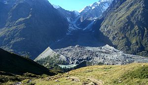
Upper area of the glacier, in the foreground Lac du Miage |
||
| location | Aosta Valley , Italy | |
| Mountains | Mont Blanc group , Graian Alps | |
| Type | Valley glacier | |
| length | 10 km | |
| surface | 11 km² | |
| Exposure | south | |
| Altitude range | 3892 m - 1700 m | |
| Coordinates | 45 ° 48 '15 " N , 6 ° 50' 26" E | |
|
|
||
| drainage | Dora di Veny ( Doire de Vény ), Dora Baltea , Po | |
The Ghiacciaio del Miage (officially French Glacier du Miage or German Miagegletscher ) is a valley glacier in the Mont Blanc massif . It is located near Courmayeur in the Italian autonomous region of Aosta Valley south of Montblanc, near the French border. At over ten kilometers, it is the longest glacier in Italy . It covers an area of around 1100 hectares , making it the third largest glacier in Italy.
The glacier has its origin in the southern flank of the Aiguille de Bionnassay , where it is still called Ghiacciaio di Bionnassay (French: Glacier de Bionnassay ). It runs from the Col de Bionnassay ( 3892 m ) west of the Aiguilles Grises and east of the south ridge of the Aiguille de Bionnassay about two kilometers to the south. The glacier is relatively steep in this area, over about two kilometers it overcomes a height difference of more than 1000 meters.
Below the Col de Miage, the glacier bends around 45 ° to the southeast at around 2800 m . From here it is called the Miagegletscher. It now flows much flatter and relatively straight about seven kilometers south-east, with an average width of 500 meters.
In the upper area it is fed by two other glaciers from the north. The Ghiacciaio del Dôme (French: Glacier du Dôme), which descends from the Dôme du Goûter, flows at around 2500 m into the Miagegletscher, at around 2400 m it is reached by the Ghiacciaio del Monte Bianco (French: Glacier du Mont Blanc), which emerges from the southwestern slopes of Mont Blanc is fed.
Below 2400 m the Ghiacciaio del Miage flows in a valley narrowed by rock walls, bounded to the west by the east face of the Petit Mont Blanc, to the east by the steep west face of Mont Brouillard .
At a height of about 2000 m it leaves the narrow rock cut and makes a bend to the east. The small Lac du Miage is located south directly on the glacier .
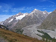
To the east, the glacier now flows about two kilometers into the Val Veny , a side valley of the Aosta Valley, where it splits into two glacier tongues. Today the glacier reaches around 1700 m . The meltwater feeds the Dora Baltea river , which flows into the Po at Crescentino .
The Ghiacciaio del Miage is almost completely covered with rubble , which provides habitat for over 80 vascular plants . The lower part of the glacier is therefore also called Giardino del Miage (French: Jardin du Miage, German: Miagegarten).
The glacier has hardly shrunk in the last 150 years.
About the Ghiacciaio del Miage hut of boarding today leads to the to 3071 m lying Refuge Francesco Gonella (sometimes Refuge du Dôme), which serves as a base for the Italian normal route of Mont Blanc. Furthermore, the approaches lead to Refuge Durier ( 3349 m ) and to the unsupervised bivouac box Refuge-Bivouac Quintino Sella ( 3396 m ) over the glacier.
Web links
Individual evidence
- ↑ Archived copy ( Memento of the original dated July 31, 2007 in the Internet Archive ) Info: The archive link was inserted automatically and has not yet been checked. Please check the original and archive link according to the instructions and then remove this notice.
- ↑ uni.kurier.magazin der Universität Erlangen-Nürnberg, p. 84 (p. 11 of the PDF file) (PDF; 2.18 MB) ( Memento from September 28, 2007 in the Internet Archive )


