Ghyaru
| Ghyaru घ्यारु |
||
|---|---|---|
|
|
||
| Coordinates | 28 ° 39 ′ N , 84 ° 8 ′ E | |
| Basic data | ||
| Country | Nepal | |
| Gandaki | ||
| Zone | Gandaki | |
| ISO 3166-2 | NP-P4 | |
| District | Manang | |
| height | 3700 m | |
| Residents | 71 (2011) | |
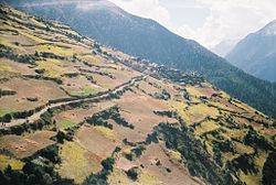
Ghyaru ( Nepali घ्यारु or Dhyaru ) is a village and Village Development Committee in the Manang District in north-central Nepal .
Ghyaru is located in the upper Manang Valley between Manang and Pisang on the Annapurna Circuit trekking route . The village lies above the northern bank of the Marsyangdi at an altitude of 3700 m .
Residents
At the 2011 census, Ghyaru had 71 inhabitants (32 of them male) in 33 households.
Web links
Commons : Ghyaru - collection of images, videos and audio files
Individual evidence
- ↑ National Population and Housing Census 2011 (PDF) Central Bureau of Statistics. Archived from the original on July 31, 2013.

