
Manang
| Manang मनाङ |
|||
|---|---|---|---|
|
|||
| Coordinates | 28 ° 40 ′ N , 84 ° 1 ′ E | ||
| Basic data | |||
| Country | Nepal | ||
| Gandaki | |||
| Zone | Gandaki | ||
| ISO 3166-2 | NP-P4 | ||
| District | Manang | ||
| height | 3519 m | ||
| Residents | 630 (2011) | ||
 |
|||

Manang ( Nepali मनाङ ), also called Manangbhot , is a village and a Village Development Committee in the Annapurna region in Nepal and about 45 km north of Pokhara .
It is an important stage of the Annapurna Circuit trekking route .
Residents
In 1991 the population was 391 people in 120 households. At the 2011 census, Manang had 630 inhabitants (373 of them male) in 131 households.
location
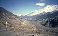
Manang is located in the wide Manang Valley on the banks of the Marsyangdi and north of the Annapurna Himal at an altitude of 3519 m . West of Manang is located at an altitude of 4920 m of Tilicho Lake , north west is the 5416 m high pass Thorong La and the north stands the 6584 m high Chulu up.
Infrastructure
The village is a trading post that is several hundred years old. In the course of time, well-maintained supply paths have emerged around them, connecting the Manang valley with the valleys of Kali Gandaki and Manaslu . With Besisahar Manang is connected by a dirt, some very adventurous scale street. As in the old days, a large part of the goods required is transported by mules , yaks or porters. 2.5 km east of the village there is a small Manang Airport and a medical center specializing in the examination of altitude sickness .
Due to the location of the place at just over 3500 m , it is advisable for hikers of the Annapurna Circuit to acclimatize to the altitude and to take a rest day in Manang on the way to Thorong La.
The inhabitants of Manang live mainly from tourism (supply and accommodation for the trekking groups). But traditional agriculture and cattle breeding (yaks) are also practiced.
Villages and Hamlets
Manang consists of several villages and hamlets :
- Bojo Gumba ( 3612 m )
- Humde ( 3390 m ⊙ )
- Manang ( 3519 m ⊙ )
- Sabjekholaga ( 3590 m )
- Tallo Humde ( 3340 m )
- Tanje ( 3463 m )
![]() Map with all coordinates of the section Villages and Hamlets : OSM
Map with all coordinates of the section Villages and Hamlets : OSM
photos

Main street of Manang

Manang from the south
Manang from the west


Web links
- Map of the Annapurna region - from www.digitalhimalaya.com. Last accessed on April 26, 2011
Individual evidence
- ^ Nepal Census Data 2001 - website from digitalhimalaya.com. Last accessed on April 26, 2011
- ↑ National Population and Housing Census 2011 (PDF) Central Bureau of Statistics. Archived from the original on July 31, 2013.
- ↑ Coordinates of Manang - website from fallingrain.com. Last accessed on April 26, 2011
- ^ District: Manang. List of Settlements (PDF) In: Index of Geographical names of Nepal . National Geographic Information Infrastructure Program. www.ngiip.gov.np. Archived from the original on February 6, 2016. Info: The archive link was inserted automatically and has not yet been checked. Please check the original and archive link according to the instructions and then remove this notice. Retrieved September 5, 2015.