Gilgandra
| Gilgandra | |||||||
|---|---|---|---|---|---|---|---|
 Main road |
|||||||
|
|||||||
|
|||||||
|
|||||||
|
|||||||
|
|
|||||||
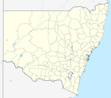
Gilgandra is the capital of the Gilgandra Shire and is located in New South Wales in Australia . The site is located on Warrumbungle National Park at the intersection of Newell Highway , Oxley Highway and Castlereagh Highway . The town is also on the Castlereagh River .
etymology
The word Gilgandra comes from the Aboriginal language and means long watering hole , which possibly stands for the Castlereagh River.
geography
The landscape around Gilgandra is very flat. The soils consist mostly of sand.
climate
During the summer high temperatures can be reached up to 40 ° C, can winter the thermometer to -2 ° C and snow fall. In 1955 the small town was hit by a flood disaster. However, the place was later ravaged by droughts.
history
Gilgandra was founded in 1888.
Sons of the city
Web links
Commons : Gilgandra, New South Wales - Collection of images, videos and audio files
Individual evidence
- ↑ Australian Bureau of Statistics : Gilgandra ( English ) In: 2016 Census QuickStats . June 27, 2017. Retrieved January 26, 2020.
