Castlereagh River (Macquarie River)
| Castlereagh River | ||
|
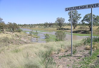
Castlereagh River from the Castlereagh Highway south of Walgett |
||
| Data | ||
| location | New South Wales , Australia | |
| River system | Murray River | |
| Drain over | Macquarie River → Barwon River → Darling River → Murray River → Indian Ocean | |
| source | east of Coonabarabran in Warrumbungle National Park 30 ° 55 ′ 54 ″ S , 148 ° 23 ′ 15 ″ E |
|
| Source height | 630 m | |
| muzzle |
Macquarie River Coordinates: 30 ° 12 ′ 0 ″ S , 147 ° 32 ′ 0 ″ E 30 ° 12 ′ 0 ″ S , 147 ° 32 ′ 0 ″ E |
|
| Mouth height | 121 m | |
| Height difference | 509 m | |
| Bottom slope | 0.94 ‰ | |
| length | 541 km | |
| Left tributaries | Bonan Creek, Terrwinda Creek, Toorawandi Creek, Ulinda Creek, Butheroo Creek, Ranters Creek, Eurimie Creek, Balagula Creek, Coolibah Creek, Nedgera Creek | |
| Right tributaries | Belar Creek, Greenbah Creek, Weeingoody Creek, Sand Creek, Breelong Creek, Ulomogo Creek, Terabile Creek, Gulargambone Creek, Wilber Creek, Baronne Creek, Werrena Creek, Duck Holes Creek, Nebea Creek, Colless Warrambool, Shepherds Warrambool, Cumbadoon Warrambool | |
| Reservoirs flowed through | Timor reservoir | |
| Medium-sized cities | Coonabarabran , Binnaway , Gilgandra , Gulargambone , Coonamble | |
| Small towns | Deringulla, Murrawal, Neilrex, Merrigoen, Mendooran, Breelong, Kamberi, Curban | |
The Castlereagh River is a river in the middle of the Australian state of New South Wales .
course
It rises in the middle of the Warrumbungle Range and initially flows east to the city of Coonabarabran . Then the river makes a loop that leads its course south, then west and finally north-west. It flows through the cities Binnaway , Mendooran , Gilgandra , Gulargambone and Coonamble , and then in the Macquarie River just before its mouth into the Barwon River , a source river of the Darling River lead to.
The Castlereagh River has a special position among the large rivers in the middle and west of New South Wales, as it does not originate in the Great Dividing Range . Therefore, the river carries very little water and its water level varies greatly over the year.
history
The Castlereagh River was explored by John Oxley in 1818.
See also
Individual evidence
- ↑ a b c Map of Castlereagh River, NSW . Bonzle.com
- ^ Search for the Inland Sea . Exploration. State Library of New South Wales ( Memento of the original from June 26, 2006 in the Internet Archive ) Info: The archive link was automatically inserted and has not yet been checked. Please check the original and archive link according to the instructions and then remove this notice.
