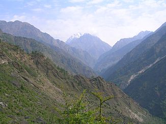
Gori (Mahakali)
|
Gori Gori Ganga, Gori Gad |
||
|
Gori river valley |
||
| Data | ||
| location | Uttarakhand ( India ) | |
| River system | Ganges | |
| Drain over | Kali → Ghaghara → Ganges → Indian Ocean | |
| origin |
Milam Glacier 30 ° 27 ′ 59 ″ N , 80 ° 6 ′ 35 ″ E |
|
| Source height | approx. 3600 m | |
| muzzle |
Kali ( Mahakali ) coordinates: 29 ° 45 ′ 0 ″ N , 80 ° 22 ′ 35 ″ E 29 ° 45 ′ 0 ″ N , 80 ° 22 ′ 35 ″ E |
|
| Mouth height | approx. 600 m | |
| Height difference | approx. 3000 m | |
| Bottom slope | approx. 30 ‰ | |
| length | 100 km | |
| Left tributaries | Gonka | |
| Communities | Milam , Madkote , Jauljibi | |
The Gori (also Gori Ganga or Gori Gad ) is a right tributary of the Kali ( Mahakali ) in the Indian state of Uttarakhand .
The Gori is fed by the Milam Glacier in the Garhwal Himalayas . In the headwaters lie the peaks Nanda Pal , Nanda Gond , Tirsuli , Hardeol and Rishi Pahar . The river flows in a south-southeast direction through the Pithoragarh district . He passes the villages of Milam and Madkote . He breaks through the mountains in a steep gorge. He then picks up the Gonka from the right . A mountain range in the east with the Panchchuli peaks separates the Gorital from the Darmatal, which runs further east. The Gori finally flows into the Kali at Jauljibi on the Nepalese border. The Gori has a length of about 100 km.
Web links
- Gori at uttarakhandphotos.blogspot.de
