Tulkarm Governorate
| محافظة طولكرم Tulkarm Governorate
|
|
|---|---|
| Basic data | |
| Country | State of Palestine |
| surface | 246 km² |
| Residents | 195,300 (2020) |
| density | 794 inhabitants per km² |
| ISO 3166-2 | PS-TBS |
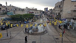
| View of Tulkarm | |
Coordinates: 32 ° 19 ′ N , 35 ° 6 ′ E
The Tulkarm Governorate ( Arabic محافظة طولكرم, DMG Muḥāfaẓat Ṭūlkarm ) is a governorate of the Palestinian Authority or the State of Palestine . It is located in the north of the West Bank . The district capital or Muhfaza (seat) is the city of Tulkarm .
According to the Palestinian Central Bureau of Statistics, the governorate had 186,760 inhabitants as of mid-2017. By 2020 this number rose to 195,300 inhabitants.
Demographics
The population is on average very young and around 33.5 percent are younger than 15 years, while only 4.3 percent are over 65 years old. In 2017, 100 percent of the population was Muslim. Residents of Jewish settlements were not included. 60.1 percent of the total population were refugees in the same year.
| Census year | population |
|---|---|
| 1997 | 134.110 |
| 2007 | 157.988 |
| 2017 | 186,760 |
places
Individual evidence
- ↑ a b Tulkarm (Governorate, Palestinian Territories) - Population Statistics, Graphics, Map and Location. Retrieved June 27, 2020 .


