
Rafah Governorate
| محافظة رفح Rafah Governorate
|
|
|---|---|
  |
|
| Basic data | |
| Country | State of Palestine |
| Capital | Rafah (Gaza Strip) |
| surface | 65 km² |
| Residents | 225,538 (2015) |
| density | 3470 inhabitants per km² |
| ISO 3166-2 | PS-RFH |
 |
|
Coordinates: 31 ° 18 ′ 0 ″ N , 34 ° 15 ′ 0 ″ E
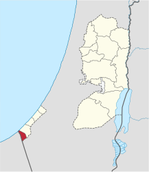
The Rafah Governorate ( Arabic محافظة رفح, DMG Muḥāfaẓat Rafaḥ ) is an administrative district of the Palestinian Authority or the State of Palestine in the southernmost part of the Gaza Strip . The district city is the city of Rafah , it is on the border with Egypt . According to the Palestinian Central Bureau of Statistics, the population of the governorate rose from 165,240 in mid-2005 to 225,538 in 2015. The Gaza governorate is closed .
Cities
- al-Bayuk
- al-Mawasi
- al-Qarya as-Suwaidiyya
- Rafah (district town)
- Shaukat as-Sufi
Refugee camp
Individual evidence
- ↑ Projected Mid-Year Population for Rafah Governorate by Locality 2004-2006 ( Memento from February 7, 2012 in the Internet Archive )
- ^ Palestinian Central Bureau of Statistics: Statistical Yearbook 2015 . P. 26
Palestine Governorates
| in the Gaza Strip |
Chan Yunis | Dair al-Balah | Gaza | North Gaza | Rafah |
|
| in the West Bank |
Bethlehem | Jenin | Hebron | Jericho | Jerusalem | Nablus | Qalqilya | Ramallah and al-Bira | Salfit | Tubas | Tulkarm |