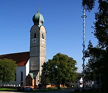
Grünthal (Unterreit)
|
Grünthal
Community Unterreit
Coordinates: 48 ° 8 ′ 27 ″ N , 12 ° 23 ′ 40 ″ E
|
|
|---|---|
| Height : | 528 m |
| Residents : | 21 (1987) |
| Incorporation : | April 1, 1971 |
| Postal code : | 83567 |
| Area code : | 08073 |
Grünthal is a district of Unterreit and a district in the Upper Bavarian district of Mühldorf am Inn .
location
The parish village is located on the open ground in the east of the municipality, on the district road MÜ 48 from Jettenbach to Waldhausen .
history
The first mention of green valley dates of 7 April 1030. Emperor Conrad II. Confirmed the Archbishop Thietmar from Salzburg to Wildbann of "Gruonintal", thus protecting the hunting reserves and above deforestation. The place name means "crooked valley" or "green valley". Grünthal was in contact with the Archdiocese of Salzburg from the start . The tower of the parish church of St. Andrew was built in 1450 and later changed to Baroque style . With the municipal edict of 1818, Grünthal became an independent municipality in the regional court Ä.O. Wasserburg with the following districts:
|
|
|
|
In 1971 it merged with neighboring communities to form the municipality of Unterreit as part of the municipal reform , the Wasserburg am Inn district was dissolved in 1972.
