
Grand Canyon-Parashant National Monument
| Grand Canyon-Parashant National Monument | |||
|---|---|---|---|
 |
|||
|
|||
| Location: | Arizona , United States | ||
| Specialty: | Desert plateau north of the Grand Canyon | ||
| Next city: | St. George | ||
| Surface: | 4,115.6 km² | ||
| Founding: | January 11, 2000 | ||
 |
|||
_location_map.svg)
Grand Canyon-Parashant National Monument is a nature reserve of the type of a national monument in the northwest of the US state Arizona . It is located in Mohave County between the north rim of the Grand Canyon and the Virgin River , near the state line with Utah , in the south it intersects with the Lake Mead National Recreation Area and borders the Grand Canyon National Park . In the west of Utah is directly adjacent to the Gold Butte National Monument .
The over 4000 km² large protected area was designated on January 11, 2000 by President Bill Clinton by Presidential Proclamation . The National Monument is under the joint administration of the National Park Service and the Bureau of Land Management , both federal agencies under the umbrella of the US Department of the Interior .
The name comes from the language of the Paiute Indians and is derived from Pawteh 'ee oasoasant , which means "tanned deerskin" and indicates that the land was more fertile in earlier times and that large herds lived on the plateau.
description
The reserve is located in the so-called Arizona Strip , the almost unpopulated and inaccessible northwestern part of Arizona, which is separated from the rest of the state by the Colorado River . Geologically, the cover rocks of the Shivwits Plateau are sedimentary rocks from the Paleozoic Era with individual younger mountains from the Mesozoic Era . The plateau slopes from north to south, and rainfalls have carved canyons into the rock, exposing older layers of the Precambrian . The National Monument only includes the top of these geological formations, the actual Grand Canyon is located in the national park of the same name to the south.
The highest points in the area are the Mount Trumbull (2447 m) and Mount Logan (2398 m) to the east and to the Virgin Mountains belonging to Black Rock Mountain (2446 m) to the north. Two major regions merge into one another in the National Monument. In the west the semi-deserts and deserts of the Sonoran Desert , Mojave Desert and the Great Basin , in the east the Colorado Plateau . Therefore, in the west of the area planted with a desert plants like cactus and yucca (also including Yucca brevifolia , English "Joshua Tree"), the higher parts of the East are partly covered by a forest, whose flagship species, the ponderosa pine is.
The subspecies Strix occidentalis lucida of the spotted owl , among others, live in the forests of the east , the transition areas serve as territory for the California condor , which was extinct in the wild in the 1980s and is currently the subject of the largest conservation breeding and reintroduction program in the United States . The only reintroduction site in Arizona is just west of the monument. The California gopher tortoise lives in the desert regions .
history
The area was only sparsely populated by the indigenous people due to the desert climate and low fertility . Individual buildings and petroglyphs of the Anasazi , as well as millstones and arrowheads are found scattered throughout the reserve.
An expedition of two Spanish Franciscan padres, Francisco Antanasio Domínguez and Silvestre Vélez de Escalante , was the first white man to pass the edge of today's protected area in 1776, and in 1826 and 1827 the trapper and explorer Jedediah Smith moved the Virgin River along the northern boundary of the monument. In the following years, the route established itself as part of the Old Spanish Trail to California . At the end of the 19th century, some ranchers settled in the region and forestry began using the forests, mainly as support beams for the ore mines of the west. The logging ended in the 1960s, and the use of public areas by cattle from private ranches that was largely free-grazing before it was placed under protection is expressly guaranteed for the future in the monument's founding documents.
Economically, the area is only moderately attractive, and tourism has hardly taken place on the north side of the Grand Canyon. There are no tourist facilities in the National Monument, and the small visitor center, which is responsible for several areas of the Bureau of Land Management , is located outside of St. George . All roads are unpaved sand and gravel roads, drinking water is only found in a few places.

Desert landscape to the west of the monument
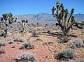
Joshua trees occur only in the southwest of the area

Native American petroglyphs in the monument

Cattle in the National Monument


Even before the National Monument was placed under protection in 1984, four sub-areas within today's boundaries ( Mount Trumbull Wilderness , Mount Logan Wilderness , Grant Wash Cliffs Wilderness and Paiute Wilderness ) were designated as wilderness areas and are still largely kept free from human influences. The Beaver Dam Mountains Wilderness borders the monument to the north.
Because President Clinton has designated the area without prior consultation with the state of Arizona, the reserve was initially sharply criticized by local politicians. A debate developed about the relationship between the federal government and the states in the west, where vast areas of public land are federally owned. When polls showed that over 75% of residents in the area approved of the National Monument, the protest fell.
Geological findings in the area indicate deposits of various mineral resources , in particular uranium deposits are suspected. Any use of these raw materials would threaten the protective purpose of the area.
See also
Other protected areas in the vicinity of the National Monument:
- Grand Canyon National Park
- Zion National Park
- Vermilion Cliffs National Monument
- Pipe Spring National Monument
Web links
- National Park Service: Grand Canyon-Parashant National Monument (official site; English)
- Bureau of Land Management: Grand Canyon-Parashant National Monument (official site )
- Land Use History of North America: Grand Canyon-Parashant National Monument ( Memento from March 16, 2015 in the Internet Archive ) - joint project of the US Geological Survey and Northern Arizona University (English)
- Wilderness.net: Information about the Wilderness Areas in the National Monument (English)