Grasberg (mountain)
| Grasberg | ||
|---|---|---|
|
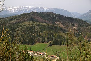
View of the Grasberg from the southeast, behind the Raxalpe |
||
| height | 1078 m above sea level A. | |
| location | Lower Austria , Austria | |
| Mountains | Edge mountains east of the Mur | |
| Dominance | 1.28 km → Mitterotter | |
| Notch height | 103 m ↓ near Schanzkapelle | |
| Coordinates | 47 ° 38 '50 " N , 15 ° 53' 46" E | |
|
|
||
The Grasberg is 1078 m above sea level. A. high mountain in the area of the municipality of Gloggnitz in southern Lower Austria, about four kilometers southwest of its center.
location
South of the Grasberg are the Otter Mountains . To the west of it is the Semmering area , including the Eselstein and Sonnwendstein mountains .
A short section of the Semmering expressway S6 between Gloggnitz and Schottwien runs in the steep north flank of the Grasberg.
Surname
The spelling Grasberg is still the most common today. However, the current version of the official Austrian map opts for the Grassberg variant ; the compass map again for the Graßberg variant .
Paths in the area of the Grasberg
The Austrian long-distance hiking trail No. 01 leads from the community of Raach am Hochgebirge via Schlagl to the Schanz chapel just south of the Grasberg and from there via Göstritz to the pilgrimage site of Maria Schutz . A marked path leads from the Schanzkapelle to the “Kummerbauer Stadl” inn. The summit of the Grasberg, however, can only be reached via unmarked trails.

