
Gratschach
|
Gratschach ( district ) locality cadastral community Gratschach |
|||
|---|---|---|---|
|
|||
| Basic data | |||
| Pole. District , state | Villach (VI), Carinthia | ||
| Judicial district | Villach | ||
| Pole. local community | Villach | ||
| Coordinates | 46 ° 38 '24 " N , 13 ° 53' 40" E | ||
| Residents of the village | 190 (January 1, 2020) | ||
| Building status | 69 (2001) | ||
| Area d. KG | 12.26 km² | ||
| Statistical identification | |||
| Locality code | 02399 | ||
| Cadastral parish number | 75415 | ||
| Counting district / district | St. Andrä (20201 280) | ||
| Source: STAT : index of places ; BEV : GEONAM ; KAGIS | |||


Gratschach is both a district and a cadastral community and a place of the statutory city of Villach . The clustered village itself is located between Landskron and the Ossiacher See , at the foot of the western foothills of the Ossiacher Tauern below the Landskron castle ruins .
history
Celtic graves are evidence of the first settlement of the place. An elite group of burial mounds from the older Hallstatt culture was excavated near Michaeler Teich . A Roman road led through the local area. Gratschach came through the Counts of Eppenstein to the Counts of Treffen. The first documentary mention took place in 1163, when Wolfrad von Treffen , his wife Hemma and their only son Ulrich II von Treffen (Patriarch of Aquileja) transferred their property in Gratschach together with Treffen and the neighboring Tiffen to the Patriarchate of Aquileja .
The inscription on the 2000-year-old cult site, next to which there is also a small church, comes from the working group and the Landskron cultural association:
“Memorial plaque to the silver mining on the southwest slope of the Ossiachertauern, on the Jungfernsprung and on the Burgberg Landskron, formerly called Scheuerberg, as well as on the Oswaldiberg and the Wollanigberg. But lead, gold and iron were also mined. The operators of this significant ore mining were among others: Aquileia, Bamberg, Salzburg, Ötting and Passau, but also the Fugger and other trades. Numerous dilapidated mine tunnels (also called Knappenlöcher) still bear witness to the great mining importance of this area. Gratschach played a major role at the time of the mining operation, which probably goes back to antiquity. Just as traces have already been uncovered, the ground here and all around may still hold some secrets. "
Filial church of Saints Philip and Jacob
The church on the outskirts is documented for the first time in 1195/1196. It is an own church of the Ossiach monastery , built in the 12th century , which is marked in the choir with the year 1512. In 1949 numerous Roman spoils were uncovered. In 1987/89 restorations and excavations were carried out.
Exterior
The building represents a small Romanesque church with a lower square choir, a wooden roof turret to the east, a pointed helmet and a wooden canopy in the west. The south wall and choir have small Romanesque windows. The branch church is covered with a shingle roof. Numerous carved fragments from a Roman tomb are cemented into the southern outer wall: fragments of pilaster, triton relief , which was severely damaged in the 2nd half of the 20th century by acts of vandalism (the raised parts of the Greek sea god blowing a horn were knocked off with a hammer) was, frieze bar with tendril ornament, dolphin relief, furthermore a fragment with an incised lamb of uncertain dating.
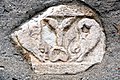
"Delphine" from Gratschach

"Lammchen" from Gratschach

Triton relief by Gratschach


Interior
Hall-like nave with wooden ceiling, semicircular triumphal arch with warriors made of Roman stone, recessed choir with flat ceiling. Remarkable wall paintings marked 1606, with strong late Gothic reminiscences; on the east side of the choir Saint Roch and Sebastian between the column architecture; on the triumphal arch on the left Anna Selbdritt, here inscribed 1606, in medallions Passion and Annunciation. In the triumphal arch, St. James with a praying pilgrim (donor?).
Reredos-like side altar (formerly high altar), marked 1653, with a remarkable picture of the mercy seat.
Good Landskron
The estate is located on Max Lauritsch-Strasse, No. 53–57 and is a free-standing, three-story, cubic building under a hipped roof; the hall presents itself with a needle cap barrel and stone-clad portals from the first half of the 18th century. The gate wall has a crenellated crown.

Landskron estate in Gratschach

Gate wall of Gut Landskron

Tablet from Gut Landskron

Chicken farm at Gut Landskron


literature
- Austrian art topography. Volume I: Herzogthum Karnten , Vienna 1889, p. 79; in commission at Kubasta & Voigt, from the KK Hof- und Staatsdruckerei.
- DEHIO Carinthia - topographical inventory of monuments , pp. 240–242. Verlag Anton Schroll & Co, Vienna 2001, ISBN 3-7031-0712-X
Web links
Individual evidence
- ↑ Cf. Karl August Muffat: The Counts of Treffen in Carinthia as a branch of the Alemannic dynasty of the Counts of Veringen-Alshausen. Munich 1855. p. 550.