Grazer Platz
| Grazer Platz | |
|---|---|
| Place in Berlin | |
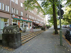
 The south side of Grazer Platz |
|
| Basic data | |
| place | Berlin |
| District | Schöneberg |
| Confluent streets |
Grazer Damm , Rubensstrasse , Riemenschneiderweg, Beckerstrasse, Pöppelmannstrasse, Kauschstrasse |
| Buildings |
Nathanael Church , Peter Paul Rubens School |
| use | |
| User groups | Pedestrians , cyclists , road traffic , public transport |
The Grazer Platz is located in Berlin's district of Schöneberg . The most striking building on the square is the Protestant Nathanael Church , built in 1903 . From 1928 onwards it was named Nathanaelplatz . After the " connection " of Austria in 1938 to the German Reich , the square was in 1939 for Graz renamed, the capital of the then Gaus and today's Austrian state of Styria .
location
The approximately 350 × 65 meter square extends between Rubensstrasse in the west and Riemenschneiderweg in the east and is cut through by the six-lane Grazer Damm . In the north and south, two one-way streets called Grazer Platz border the green area. Side streets of Grazer Platz are Pöppelmannstrasse in the north and Kauschstrasse in the south. Coming from the Friedenauer Brücke, Beckerstrasse runs directly towards the Nathanael Church and joins Rubensstrasse at Grazer Platz at right angles.

About half of the western part of the square is taken up by the Nathanael Church, the facade of which faces a small forecourt on Rubensstrasse. The area on the west side of Rubensstrasse was built on during the Wilhelminian era . The Nathanael Church was built between 1902 and 1903 according to a design by Jürgen Kröger as a place of worship for the population of this area . It is consecrated to the disciple Nathanael and is used by the evangelical Philippus Nathanael congregation. Originally the Nathanael Church had a tall, pointed steeple. This was damaged in World War II and then rebuilt in a more modest form. Behind the church a green area with a large meadow extends to Grazer Damm.
On the south side of the square bordering Rubensstrasse there is the parish hall of the Philippus Nathanael congregation, which was built in 1928 according to plans by architects Peter Jürgensen and Heinrich Seidel , and the former Barnim primary school on the north side. The Barnim School and the former Uckermark School on Rubensstrasse were merged as elementary schools in the summer of 2006 as the Peter Paul Rubens School .
The street blocks around Grazer Platz are occupied by the settlement on Grazer Damm. This was built in the late 1930s and is one of the few examples of housing architecture from the National Socialist era. Retail and catering companies are located on the ground floor of the side of the residential buildings facing Grazer Platz.
The plaza in the eastern part between Grazer Damm and Riemenschneiderweg is younger than the western part and was only created during the course of the construction of the settlement. A mosaic with the coat of arms of the eponymous city of Graz is embedded in the ground on Grazer Damm . Today there is a children's playground, a skateboard area and a football field in the eastern part of Grazer Platz . At the east end of the square, on the opposite side of the Riemenschneiderweg, an allotment garden colony begins.
Historical
A five-month trade exhibition took place in 1907 on the then undeveloped site between Vorarlberger Damm and Peter-Vischer-Straße, which also included today's Grazer Platz. "Wild Africa" and "American amusement war games" were presented at the German Army, Military and Colonial Exhibition . At the same time, companies presented their products from military accessories as well as everyday accessories suitable for tropical and colonial times. The location was chosen because of the close proximity to the barracks on General-Pape-Straße and Tempelhofer Feld , where the imperial troops held their parades . The Nathanael Church, which was only three years old at the time, suddenly found itself in the immediate vicinity of the “Wild Africa” exhibition area.
literature
- Gudrun Blankenburg: Friedenau - artist's place and idyllic residential area. The history of a Berlin district . Frieling, Berlin 2006. ISBN 3-8280-2350-9 (with register and enclosed monument map)
Web links
-
Grazer Platz. In: Street name lexicon of the Luisenstädtischer Bildungsverein (near Kaupert )
- Nathanael Square . In: Luise.
Individual evidence
Coordinates: 52 ° 28 '2 " N , 13 ° 20' 48" E
