Grebenhagen (Schwarzenborn)
|
Grebenhagen
City of Schwarzenborn
Coordinates: 50 ° 54 ′ 59 " N , 9 ° 28 ′ 45" E
|
|
|---|---|
| Height : | 391 (389-417) m |
| Area : | 5.6 km² |
| Residents : | 180 |
| Population density : | 32 inhabitants / km² |
| Incorporation : | 1st January 1974 |
| Postal code : | 34639 |
| Area code : | 05686 |
|
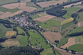
Grebenhagen from above
|
|
Grebenhagen is a district of Schwarzenborn in the north Hessian Schwalm-Eder district .
Grebenhagen is located in the Knüllgebirge on the Efze am Knüllköpfchen . The state roads 3154 and 3155 meet in the village .
The village was first mentioned in a document in 1250.
On January 1, 1974, as part of the regional reform in Hesse, the previously independent municipality of Grebenhagen from the Fritzlar-Homberg district was incorporated into the city of Schwarzenborn by state law .
For the cultural monuments of the place see the list of cultural monuments in Grebenhagen .
literature
- Literature about Grebenhagen in the Hessian Bibliography
- Search for Grebenhagen (Schwarzenborn) in the archive portal-D of the German Digital Library
Web links
- Internet presence of the city of Schwarzenborn
- Grebenhagen, Schwalm-Eder district. Historical local dictionary for Hessen. In: Landesgeschichtliches Informationssystem Hessen (LAGIS).
Footnotes
- ↑ The place name has been rendered differently over time: 1250 Grebenhain, 1457 Gryffenhain, 1504 Grebenhaun, 1611 Grevenhann, 1780 Grebenhagen, Grebenhayn (LAGIS).
- ↑ Law on the reorganization of the districts Fritzlar-Homberg, Melsungen and Ziegenhain (GVBl. II 330-22) of September 28, 1973 . In: The Hessian Minister of the Interior (ed.): Law and Ordinance Gazette for the State of Hesse . 1973 No. 25 , p. 356 , § 7 ( online at the information system of the Hessian state parliament [PDF; 2,3 MB ]).
