Knüllköpfchen
| Knüllköpfchen (Knüllköpfchen) | ||
|---|---|---|
|
Knüllköpfchen with the neighboring mountain to the east (Waldknüll) |
||
| height | 633.8 m above sea level NHN | |
| location | Schwalm-Eder-Kreis , Hessen ( Germany ) | |
| Mountains | Knüllgebirge | |
| Coordinates | 50 ° 55 ′ 0 ″ N , 9 ° 25 ′ 20 ″ E | |
|
|
||
| Type | extinct stratovolcano | |
| rock | Sandstone with basalt breakthrough | |
| particularities | - August-Franke-Turm ( AT ) - radio tower |
|
The Knüllköpfchen , also called Knüllkopf , is an extinct volcano and at 633.8 m above sea level. NHN the second highest mountain of the Knüllgebirge ( Knüll ) and belongs to the Schwalm-Eder district in northern Hesse , Germany .
Since the mountains were defined in a much narrower area until the 20th century, the Knüllköpfchen is also referred to in some sources as the highest mountain in the Knüllgebirge.
Geographical location
The Knüllköpfchen is located in the northwest part of the district of Schwarzenborn . The mountain is located about 20.5 km (as the crow flies ) west of Bad Hersfeld , 14.5 km east of Schwalmstadt and 13 km south of Homberg (Efze) . The core town of Schwarzenborn, with its hamlet Richberg on the north-western slope, is just 1.9 km southeast of its summit , and the Eisenberg ( 635.5 m above sea level ) rises about 7.5 km southeast as the highest mountain in the Knüllgebirge . The Hergetsbach rises on the northern slope of the Knüllköpfchen , on the southern slope one of two source streams the Efze and on the western slope the Steina . The neighboring mountain to the east is the Waldknüll ( 624.4 m above sea level ).
Infrastructure and culture
In the immediate vicinity of the summit is the Boglerhaus, a youth hostel with an attached restaurant. It stands on the site of the former Bogler-Kate, which belonged to the painter of the crumpled landscape, Friedrich Wilhelm Bogler . The parking lot at the Boglerhaus can be reached via the country road from Ziegenhain to Schwarzenborn or from the west and northwest via the country road from Frielendorf . Next to the Boglerhaus is the KnuellCamp, a Christian leisure and educational center with a campsite and a snack station . The information center of the Knüllgebirgsverein is located right next to the site next to the steel lattice tower , on the northwest slope there is a small wind park with five wind turbines and the hamlet of Richberg.
The nationally known summer music festival, which was previously held on Mosenberg near Homberg (Efze) , took place annually between 2006 and 2018 in the KnüllCamp and in the Boglerhaus.
Towers
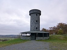
There is a 12 meter high observation tower on the mountain . Erected in 1978 as a Knüllenurm , it was renamed the August Franke Tower in 1984 . Furthermore, to the west, a little below the summit, there is a 46-meter-high transmission tower of the German Federal Post Office made of steel framework construction . It is used for radio transmission and is also used by a local section of the amateur radio club.
activities
The mountain is a popular excursion destination in the region, with a well-developed network of hiking trails such as the Löwenweg , which opens up the entire Knüll. The Knüllgebirgsverein has maintained an information center with an archive on the mountain since 2007. There is a groomed trail in winter .
See also
Web links
Individual evidence
- ↑ Map services of the Federal Agency for Nature Conservation ( information )
- ↑ Picture gallery - The Knüllköpfchen near Schwarzenborn> Photos of the memorial plaques on zu-gast-in-schwarzenborn.de


