
Otter (mountain)
| Big otter | ||
|---|---|---|
 The western slope of the Great Otter as seen from the meadow near the Sattel (between the Gr. Otter and Mitterotter) |
||
| height | 1358 m above sea level A. | |
| location | Lower Austria , Austria | |
| Mountains | Semmering area , foothills east of the Mur , Central Alps | |
| Dominance | 3.6 km → Sonnwendstein | |
| Notch height | 279 m ↓ Kummerbauerstadl | |
| Coordinates | 47 ° 37 '48 " N , 15 ° 54' 54" E | |
|
||

The Otter is a mountain in southern Lower Austria between the Semmering - Rax - Schneeberg region in the northwest and the Bucklige Welt in the southeast.
description
The town of Gloggnitz is located at the foot of the otter in the north . In the south, the Feistritztal at the foot of the Otter stretches from Feistritzsattel in the west via Trattenbach and Otterthal to the east to Aspang-Markt .
The Otter mountain group consists of three peaks, which are arranged exactly in an east-west direction:
- Great Otter ( 1358 m )
- Mitterotter ( 1297 m )
- Little Otter ( 1327 m )
Ascents
The summit of the Großer Otter can be reached largely via forest roads from Schlagl in the north, from Otterthal in the east and from the Gasthaus Kummerbauerstadl in the southwest. All routes are unmarked; From Schlagl, however, several signposts show the right way. The rounded summit of the Great Otter is currently (as of 2018) almost tree-free and therefore offers a clear view of the Vienna Basin , the Raxalpe and the Schneeberg .
The small otter and the mitter otter form narrow, wooded summit ridges and can be climbed using trails.
geology
The area of the Great Otter and the Graßberg in front of it in the north is formed by weakly metamorphic carbonate rocks from the Semmering Mesozoic.
caves
In the southeast slope of the Great Otter there are twelve, mainly shaft-like, caves. The largest cave is the Otterkluft ( 2862/12 ) with 576 m length and 55 m depth, which is in connection with the Otterhöhle I (2862/7). In 1982, by removing a terminal block in the Otter Cave I, which was previously only 6 m long, large-scale cave parts were discovered where a connection with the Otter Gorge was previously suspected. In the winter of 1983/84 the entry shaft of Otterhöhle I collapsed, so it was necessary to look for a connection between the two caves, which was achieved in 1984. Since then, access has only been possible via the Otterkluft. The next three largest caves are the Otterschacht (2862/3) with 98 m length and 57 m depth, the marked wind hole (2862/6) with 248 m length and 44 m height difference (+21 m, −23 m), and the spider labyrinth (2862/10) with a length of 278 m and a depth of 59 m. Another shaft cave is the Ruprechtsloch (2862/4) made famous by its cave legend.
There are 15 caves between Göstritz and the Schanzkapelle on the steep, forested eastern slope of the Kleiner Otter. The labyrinthine entrenchment cave (2862/5) is the largest at 52 m in length.
Picture gallery
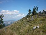
The summit of the Great Otter
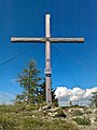
The summit cross
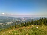
View of the Vienna Basin , Gloggnitz can be seen on the left .

The manhole of the marked wind hole (2862/6)

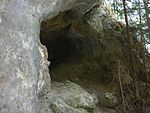
The small entrance to the spider labyrinth (2862/10), which is located in a sinkhole .

Looking up from the 1st shaft in the spider labyrinth.

"Stone Bridge" on the southern slope of the Great Otter
The entrenchment cave portal (2862/5).


swell
- Max H. Fink, Helga and Wilhelm Hartmann (Red.): The caves of Lower Austria.
- Otterkluft: Vol. 1 (p. 237 with cave plan floor plan and elevation), Vol. 4 (p. 455 to 458 with cave plan floor plan and elevation)
- Otterhöhle I: Vol. 1 (p. 235), Vol. 4 (p. 454)
- Otterschacht: Vol. 1 (p. 233 with cave plan floor plan and elevation)
- Marked wind hole: Vol. 1 (p. 234 with cave plan floor plan), Vol. 4 (p. 454 with cave plan floor plan and elevation)
- Spider Labyrinth: Vol. 1 (p. 235 and 236 with cave plan floor plan and elevation), Vol. 4 (p. 454)
- Entrenchment cave: Vol. 1 (p. 234), Vol. 4 (p. 454)
For all caves of subgroup 2862 see vol. 1 (pp. 231 to 242), vol. 4 (pp. 452 to 465) and vol. 5 (pp. 459 to 464).
Web links
- Pictures and elevation profile on wandertipp.de
- Cave legend about the Ruprechtsloch