Groveland, Massachusetts
| Groveland | ||
|---|---|---|
| Nickname : G-Land | ||
|
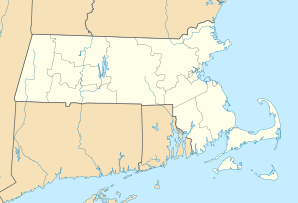
Location in Massachusetts
|
||
| Basic data | ||
| Foundation : | 1639 | |
| State : | United States | |
| State : | Massachusetts | |
| County : | Essex County | |
| Coordinates : | 42 ° 46 ′ N , 71 ° 2 ′ W | |
| Time zone : | Eastern ( UTC − 5 / −4 ) | |
| Residents : | 6,038 (as of: 2000) | |
| Population density : | 260.3 inhabitants per km 2 | |
| Area : | 24.4 km 2 (approx. 9 mi 2 ) of which 23.2 km 2 (approx. 9 mi 2 ) is land |
|
| Height : | 15 m | |
| Postal code : | 01834 | |
| Area code : | +1 351,978 | |
| FIPS : | 25-27620 | |
| GNIS ID : | 0618298 | |
| Website : | www.grovelandma.com | |
Groveland, Massachusetts is a small town in New England in the state of Massachusetts on the east coast of the United States . It is located in northern Essex County , bordering Boxford , Georgetown , Haverhill , and West Newbury . The city is divided into two districts, Groveland and South Groveland and is part of the 6th constituency of Massachusetts (Massachusetts's 6th congressional district).
history
Groveland was originally the eastern part of the parish of Bradford , which was part of the town of Rowley . Before Bradford was separated from Rowley in 1672 and renamed Bradford, the place was called Rowley on the Merrimack , or just Merrimack (on the Merrimack River ). Bradford was incorporated into Haverhill in 1897 . Groveland was raised to an independent city of Massachusetts on September 9, 1850 , which is why this day is celebrated as Groveland Day by the residents.
In December 1638, after seventeen years of service, pastor and Puritan Ezekiel Rogers was relieved of his position as pastor in the English Ward of Rowley , Yorkshire. He left England with twenty families. In 1638 they reached Salem in America and, after a short stay in New Haven, decided the following summer to found a new settlement on the banks of the Merrimack River north of Boston . For £ 800 the settler group - now grown to 60 families - bought land from the towns of Ipswich and Newbury and founded the new settlement in the spring of 1639, named Rowley after the place of origin of the settlers . In September 1639 the city was officially founded.
The Congregational Church of Groveland has a church bell that of Paul Revere was poured. Of the 900 bells made by Revere's company, this is the only remaining bell that still rings. The oldest hand fire pump in the country from 1798 is on display in the town hall . It was originally called "TORRENT" by Roxbury, MA, then moved to Bradford, MA in 1828 and incorporated into "Engine 2." renamed and finally from 1850 "VETO." called.
geography
The city of Groveland has an area of 24.4 km², which is divided into 23.2 km² of land and 1.2 km² of water (4.99%). It is on the Merrimack River .
politics
Groveland is in the form of the People's Assembly rules (open town meeting), typical of New England 's. The city is managed by a committee of the city councils (board of selectman), which consists of three members - one member of this committee is re-elected for three years at an annual city meeting. The city councils share the powers (municipal authority) with the municipal legislative body (legislative body), the town meeting (town meeting) and other elected boards (elected boards).
The city councils are responsible for all government duties, such as holding elections. In cooperation with the city treasurer (Finance Director), city accountant and with members of the Finance Committee (Finance Committee) they draw up the annual operating budget of the city. Every July 1st of each year, city councils appoint committee members, approve the recruitment of city officials, hold public hearings on major city issues, and enact municipal ordinances. The city council committee meets every two weeks on Mondays for public meetings in the evening at 6 p.m. (unless otherwise announced).
Transportation and traffic systems
Downtown Groveland is marked by the intersection of Massachusetts State Routes 97 and 113 . The only traffic light in town is at this intersection. Also in the city center is the Groveland Bridge, which spans the Merrimack River and connects Groveland to Haverhill .
The Georgetown – Bradford railway , which ran through the town, was in operation from 1851 to 1941.
Attractions
- Elm Park
- Elm Park: Originally laid out in 1832 as a Constitution Park; Renamed in 1857 with plants from elms, which died of elm in the 1950s. The park was re-established in the 1990s with a resistant elm variety.
- Town Hall
- The large windows of the town hall allow a view of historical artifacts including the "VETO" fire pump.
education
Groveland is part of the Pentucket Regional School District and has the following schools:
- Bagnall Elementary School
- Pentucket Regional Middle School
- Pentucket Regional High School
Web links
- Official site of the City of Groveland, MA.
- Grovelands Library.
- Groveland's historical society.
- Map of the Groveland Map from the 1884 Atlas of Essex County.
- City guide from masscities.com.
References
- ^ Ronald D. Karr: The Rail Lines of Southern New England. A Handbook of Railroad History. Branch Line Press, Pepperell MA, 1995. Pages 245ff.
