Guabirá
| Guabirá | ||
|---|---|---|
| Basic data | ||
| Residents (state) | 1691 pop. (2001 census) | |
| height | 291 m | |
| Telephone code | +591 (3) 923- | |
| Coordinates | 17 ° 19 ′ S , 63 ° 16 ′ W | |
|
|
||
| politics | ||
| Department | Santa Cruz | |
| province | Obispo Santistevan Province | |
| climate | ||
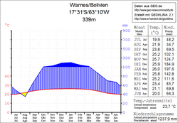
 Climate diagram Warnes |
||
Guabirá was an independent village in the Santa Cruz Department in the South American Andean state of Bolivia .
Location in the vicinity
On June 15, 1962 , the municipality "Villa Fátima" was founded in the district ( Bolivian : Municipio ) Montero in the province of Obispo Santistevan , a few kilometers north of the city of Montero , today's "Guabirá", which today is largely under the municipal administration of Montero falls and is practically a suburb of the city.
Guabirá is located at an altitude of 291 m on the northern edge of Montero and is of national importance in several ways:
- Guabirá (Villa Fátima) is an important crossing point within the highway network of Bolivia, here the two west-east running highways Ruta 4 and Ruta 10 meet .
- Guabirá has been the industrial site of Ingenio Azucarero "Guabirá" since 1953 and represents an important part of the sugar and alcohol production in Bolivia.
- Guabirá is a Bolivian football club from Montero that currently plays in the Santa Cruz Primera A, one of the regional second leagues.
geography
Guabirá is located in the tropical humid climate off the eastern edge of the Andes mountain range of the Cordillera Oriental . The region was covered by subtropical rainforest before colonization , but is now mostly cultivated land .
The mean average temperature of the region is just under 24 ° C (see Warnes climate diagram), the monthly values fluctuate between 20 ° C in June / July and 26 ° C from November to February. The annual precipitation is about 1300 mm, the monthly precipitation is productive and lies between 35 mm in August and 200 mm in January.
Transport network
The national highways Ruta 4 and Ruta 10 run through Guabirá .
The 1657 km long Ruta 4 crosses the country in a west-east direction from the Chilean border in the Oruro department to the Brazilian border in the southern tip of the Santa Cruz department and connects the two metropolitan regions of Cochabamba and Santa Cruz .
The Ruta 10 has a length of 774 kilometers and also extends in an east-west direction, it connects the colonization areas between Piray River and Rio Grande north of Guabirá with Chiquitanía - and Pantanal regions in the eastern part of the department of Santa Cruz.
population
Guabirá (Villa Fátima) had a population of 1,691 at the last census of 2001 .
Individual evidence
Web links
- Relief map of the Santa Cruz region 1: 250,000 (PDF; 7.88 MB)
- Municipio Montero - General Maps No. 71001
- Municipio Montero - detailed map and population data (PDF; 555 kB) ( Spanish )
- Department Santa Cruz - Social data of the municipalities (PDF; 4.99 MB) ( Spanish )
