Guayaramerín
| Guayaramerín | ||
|---|---|---|
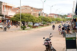
 Street scene in Guayaramerín |
||
| Basic data | ||
| Residents (state) | 35,764 inhabitants (2012 census) | |
| rank | Rank 22 | |
| height | 133 m | |
| Post Code | 08-0202-0100-1001 | |
| Telephone code | (+591) | |
| Coordinates | 10 ° 50 ′ S , 65 ° 21 ′ W | |
|
|
||
| politics | ||
| Department | Beni | |
| province | Province of Vaca Díez | |
| climate | ||
 Climate diagram Riberalta |
||
Guayaramerín is a medium- sized town in the Beni department in the lowlands of the South American landlocked state of Bolivia .
Location in the vicinity
Guayaramerín is the central place of the canton of the same name Guayaramerín in the district ( Bolivian : Municipio ) Guayaramerín in the province Vaca Díez at an altitude of 133 m on the left bank of the Río Mamoré opposite the Brazilian city Guajará-Mirim . The small river Arroyo Las Arenas flows through the city, which flows into the Río Mamoré from the west near Guayaramerín.
geography
Guayaramerín is located in the Bolivian lowlands on the border with the Republic of Brazil . The region has a tropical, hot and humid climate all year round .
The annual average temperature is 27.1 ° C (see climate diagram Riberalta), with the monthly average temperatures between June / July at a good 25 ° C and September / October at a good 28 ° C only slightly different. The annual precipitation is almost 2000 mm and is therefore more than twice as high as the precipitation in Central Europe. Highs of almost 300 mm in the months of December to February contrasted with low values of under 50 mm in June / August.
Transport network
Guayaramerín is located 617 kilometers by road north of Trinidad , the capital of the Beni department.
Guayaramerín is the end point of the 1631 kilometer long highway Ruta 9 , which begins in the south on the border with Argentina at Yacuiba and leads via Trinidad and San Ramón to Guayaramerín .
The Ruta 8 leads from Guayaramerín via Riberalta and Rurrenabaque towards La Paz . So far only the 90 kilometers to Riberalta are paved.
population
The city's population has almost tripled over the past few decades:
| year | Residents | source |
|---|---|---|
| 1976 | 12 504 | census |
| 1992 | 27 706 | census |
| 2001 | 33 095 | census |
| 2012 | 35 764 | census |
Individual evidence
- ↑ Thomas Brinkhoff: City Population
- ↑ INE - Instituto Nacional de Estadística Bolivia 1992 ( Memento of the original from April 23, 2014 in the Internet Archive ) Info: The archive link was inserted automatically and has not yet been checked. Please check the original and archive link according to the instructions and then remove this notice.
- ↑ INE - Instituto Nacional de Estadística Bolivia 2001 ( Memento of the original from September 24, 2015 in the Internet Archive ) Info: The archive link has been inserted automatically and has not yet been checked. Please check the original and archive link according to the instructions and then remove this notice.
- ↑ INE - Instituto Nacional de Estadística Bolivia 2012 ( Memento of the original from March 4, 2016 in the Internet Archive ) Info: The archive link was inserted automatically and has not yet been checked. Please check the original and archive link according to the instructions and then remove this notice.
Web links
- Guayaramerìn region - topographic map 1: 100,000 (PDF; 5.8 MB)
- Municipio Guayaramerín - General Maps No. 80202
- Municipio Guayaramerín - detailed map and population data (PDF; 1.1 MB) ( Spanish )
- Departamento Beni - Social data of the municipalities (PDF; 3.8 MB) ( Spanish )

