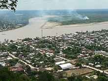
Rurrenabaque
| Rurrenabaque | ||
|---|---|---|
 Main street of Rurrenabaque |
||
| Basic data | ||
| Residents (state) | 13,446 pop. (2012 census) | |
| rank | Rank 44 | |
| height | 205 m | |
| Post Code | 08-0304-0102-7001 | |
| Telephone code | +591 (3) 892- | |
| Coordinates | 14 ° 26 ′ S , 67 ° 32 ′ W | |
|
|
||
| politics | ||
| Department | Beni | |
| province | Ballivián Province | |
| climate | ||
 Climate diagram Rurrenabaque |
||
Rurrenabaque (also called Rurre ) is a small town in the Beni department in the lowlands of Bolivia . Rurrenabaque was founded on February 2, 1844 . The place name comes from the local Tacana Indian language and means "duck pond".
Location in the vicinity
Rurrenabaque is the seat of the administration of the municipality of the same name and is located in the province of Ballivián at an altitude of 172 m , on the right bank of the Río Beni , the border river to the department of La Paz , which passes the Angosto del Bala 16 km upstream . Rurrenabaque is about 40 kilometers south of the provincial capital Reyes , and about 450 kilometers north of the government seat of La Paz .
geography
Rurrenabaque is located on the western edge of the Moxos plain , with over 100,000 km² one of the largest wetlands on earth; the predominant form of vegetation in the Moxos plain is the tropical savannah . The climate in the Rurrenabaque region is tropical hot and humid all year round, but it can also get relatively cool in winter due to the Surazo (cold wind from the south). Annual rainfall is just under 2,000 mm, with monthly rainfall of around 300 mm in January and February, and less than 100 mm in the months of August to September. The monthly average temperatures are between 23 ° C and 28 ° C all year round.
population
The city's population has increased several times over in the past three and a half decades:
| year | Residents | source |
|---|---|---|
| 1976 | 2 052 | census |
| 1992 | 4,959 | census |
| 2001 | 8 460 | census |
| 2012 | 13 446 | census |
economy

Rurrenabaque is connected to Trinidad , La Paz and Riberalta by land by roads . The Rurrenabaque airfield has the IATA code RBQ. The place is characterized by tourism and serves as a starting point for tours in the nearby Madidi National Park as well as in the animal-rich swamp areas, the so-called "pampas".
tourism
Rurrenabaque has developed into one of the most important tourist destinations in Bolivia due to its rainforests, rivers and pampas and sustainable tourism projects . The city is the starting point for tours into the surrounding pampas and the unique Madidi National Park, which is home to more protected animal species than in any other national park in the world. Every year over 12,000 (as of 1999) visitors come to Rurrenabaque. The discovery for tourism began in 1982 when tourists got lost in the jungle and only two of them survived. Yossi Ghinsberg, an Israeli tourist with the troops, only found his way back to civilization after three weeks. He wrote a book ( Lost in the Jungle ) about his experiences, which became a box-office hit and gave a decisive impetus to tourism in the region. The events were filmed in 2017, but the shooting of Jungle took place in Australia.
Web links
- Region Apolo - relief map 1: 250,000 (PDF; 6.03 MB)
- Municipio Rurrenabaque - General Maps No. 80304
- Municipio Rurrenabaque - detailed map and population data (PDF; 723 kB) ( Spanish )
- Departamento Beni - social data of the municipalities (PDF; 3.82 MB) ( Spanish )
Individual evidence
- ↑ Thomas Brinkhoff: City Population
- ^ INE - Instituto Nacional de Estadística Bolivia 1992
- ^ INE - Instituto Nacional de Estadística Bolivia 2001
- ↑ INE - Instituto Nacional de Estadística Bolivia 2012 ( Memento of the original from March 4, 2016 in the Internet Archive ) Info: The archive link was inserted automatically and has not yet been checked. Please check the original and archive link according to the instructions and then remove this notice.

