
Guilberville
| Guilberville | ||
|---|---|---|
|
||
| local community | Torigny-les-Villes | |
| region | Normandy | |
| Department | Some | |
| Arrondissement | Saint-Lô | |
| Coordinates | 48 ° 59 ′ N , 0 ° 57 ′ W | |
| Post Code | 50160 | |
| Former INSEE code | 50224 | |
| Incorporation | January 1, 2016 | |
| status | Commune déléguée | |

Guilberville is a village in Normandy in France . The municipality , which existed until January 1, 2016, belonged to the canton of Torigni-sur-Vire and was converted to the canton of Condé-sur-Vire in 2015 . It was incorporated into the Commune nouvelle Torigny-les-Villes by decree of September 28, 2015 . Since then it has been a commune déléguée with 1,211 inhabitants (as of January 1, 2017).
geography
The A84 autoroute runs through Guilberville . Neighboring communities were Giéville and Saint-Amand in the north, Placy-Montaigu and Saint-Martin-des-Besaces in the north-east, Mont-Bertrand in the east, Campeaux in the south-east, Bures-les-Monts in the south, Pont-Farcy (today: Tessy- Bocage ) in the southwest and Beuvrigny and Saint-Louet-sur-Vire in the west.
The Commune déléguée covers 22.15 square kilometers. The lowest point is at 70 and the highest at 262 meters above sea level.
Population development
| year | 1962 | 1968 | 1975 | 1982 | 1990 | 1999 | 2008 |
|---|---|---|---|---|---|---|---|
| Residents | 988 | 983 | 887 | 838 | 852 | 821 | 937 |
Attractions
- Saint-Mathurin Church
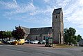
Saint-Mathurin Church

former town hall ( Mairie )
.jpg)
