
Gyugy
| Gyugy | |||||
|
|||||
| Basic data | |||||
|---|---|---|---|---|---|
| State : | Hungary | ||||
| Region : | Southern Transdanubia | ||||
| County : | Somogy | ||||
| Small area until December 31, 2012 : | Lengyeltóti | ||||
| District since 1.1.2013 : | Fonyód | ||||
| Coordinates : | 46 ° 41 ′ N , 17 ° 41 ′ E | ||||
| Area : | 15.31 km² | ||||
| Residents : | 269 (Jan. 1, 2011) | ||||
| Population density : | 18 inhabitants per km² | ||||
| Telephone code : | (+36) 85 | ||||
| Postal code : | 8692 | ||||
| KSH kódja: | 23904 | ||||
| Structure and administration (as of 2020) | |||||
| Community type : | local community | ||||
| Mayor : | György Jelenka (Fidesz-KDNP) | ||||
| Postal address : | Fő utca 19 8692 Gyugy |
||||
| Website : | |||||
| (Source: A Magyar Köztársaság helységnévkönyve 2011. január 1st at Központi statisztikai hivatal ) | |||||


Gyugy is a Hungarian community in the county Fonyód in Somogy county .
Geographical location
Gyugy is about ten kilometers south of Lake Balaton and four kilometers northeast of the city of Lengyeltóti .
Attractions
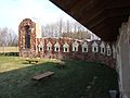
- Bell tower ( Harangláb ) from the 18th century
- Calvary
- Roman Catholic Church Urunk mennybemenetele from the Árpád age , built in the first half of the 13th century, expanded in the 14th century
- Kacskovics Castle ( Kacskovics-kastély ), built in 1865
traffic
Gyugy can only be reached via the secondary road No. 67116. The nearest train station is in Lengyeltóti.
photos

Roman Catholic Church Urunk mennybemenetele

Bell tower in Gyugy
Urn wall in Gyugy


Individual evidence
- ↑ Öt Èvre kaptak bizalmat a somogyi polgármesterek. sonline.hu, October 14, 2019, accessed on February 26, 2020 (Hungarian).
Web links
- Official website ( Hungarian )
- Gyugy in A Pallas nagy lexikona (Hungarian)