Hüngringhausen
|
Hüngringhausen
City of Bergneustadt
Coordinates: 51 ° 0 ′ 6 ″ N , 7 ° 40 ′ 18 ″ E
|
|
|---|---|
| Height : | 385 m above sea level NN |
| Residents : | 74 (May 31, 2017) |
| Postal code : | 51702 |
| Area code : | 02265 |
|
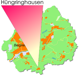
Location of Hüngringhausen in Bergneustadt
|
|
Hüngringhausen is one of 22 districts of the city of Bergneustadt in the Oberbergischer Kreis in the administrative district of Cologne in North Rhine-Westphalia , Germany .
Location and description
The place is about 4.7 kilometers away from the city of Bergneustadt (about 3 kilometers as the crow flies).
history
Before the local reorganization in 1969, Hüngringhausen was part of the old community of Eckenhagen.
First mention
The place was first mentioned in a document in 1450 .
"Peter (v.) Hunger kusen is as servants v of the beard. Nesselrode. "
The spelling of the first mention was Hungerkusen .
leisure
Hüngringhausen is an excellent starting point for long hikes. The signposted hiking car park between Baldenberg and Hüngringhausen offers a grandiose landscape panorama at an altitude of Oberberg. The well-developed hiking trail leads past the tranquil, natural town of Hünringhausen to the neighboring holiday community of Reichshof.
Bike paths
Hüngringhausen crosses one of the themed bike tours of the Reichshof community.
Tour de Eckenhagen
This tour is the second longest tour of the bicycle park and, with an altitude difference of 550 meters and inclines of over 10 percent, guarantees even experienced cyclists a lot of fun.
Starting point is Rodener Platz in Eckenhagen
| Route name | Waymarks | Driving distance | Path length |
| Tour de Eckenhagen |
Wehnrath - Schönenbach - Middle excavator - Upper excavator Hüngringhausen - Hecke - Eckenhagen |
25 km |

