
Hair (river)
| Hair | ||
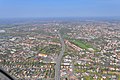
 Channeled hair in the Haarentorviertel of Oldenburg; left: Ofener Straße, right: Haarenufer (street name). Bottom right: Cäcilienschule , top right: Herbartgymnasium |
||
| Data | ||
| location | Ammerland and Oldenburg (Oldenburg) , Lower Saxony | |
| River system | Weser | |
| Drain over | Hunte → Weser → North Sea | |
| origin | The confluence of the Jücker Bäke and the other stream at Rastede 53 ° 13 ′ 35 ″ N , 8 ° 10 ′ 40 ″ E |
|
| Source height | approx. 19 m above sea level NN | |
| muzzle | in Oldenburg (Oldenburg) in the city harbor (zur Hunte ) Coordinates: 53 ° 8 ′ 25 ″ N , 8 ° 13 ′ 12 ″ E 53 ° 8 ′ 25 ″ N , 8 ° 13 ′ 12 ″ E |
|
| Mouth height | approx. 0 m above sea level NN | |
| Height difference | approx. 19 m | |
| Bottom slope | approx. 0.79 ‰ | |
| length | 24 km | |
| Catchment area | 115 km² | |
The Haaren is an approximately 24 km long tributary of the lower Hunte .
General
The hair that rises in north-west Lower Saxony on the Oldenburg-East Frisian Geest has a length of 23.8 km and a catchment area of 115 km². Of these, 75 km² are in the Ammerland district and around 40 km² in the area of the city of Oldenburg. It is the only river in the Ammerland Geest that drains over the Hunte into the left-hand basin of the Weser . The entire water system of the hair is very little natural and structurally strongly shaped today. The Haaren-Wasseracht based in Petersfehn is responsible for the water maintenance .
course
The hair rises without a source near Rastede (+19 m above sea level) in the district of Ammerland and flows through small glacial valleys first from northeast to southwest through the municipality of Wiefelstede , before it bends east in the municipality of Bad Zwischenahn near Petersfehn into lower, heavily drained moorland areas . Here the hair reaches the urban area of Oldenburg , where it cuts deep into the Geest there (inner-city hair low: +2.50 to +2.75 m above sea level). In the center of the city of Oldenburg, the Haaren flows into the tidal Hunte via a sluice and estuary pumping station at the dam .
Hair in the west of Oldenburg (parallel to the lower edge of the picture)
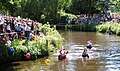
Wash tub regatta on the Haaren in Oldenburg near Heiligengeistwall

Channeled hair between the reservoir (left) and the reservoir line (right) just before the Oldenburg harbor
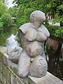
Sculpture Neptune and Mermaids or river god with hair and house bakeries in Roonstraße in OL

Pedestrian bridge over the Haaren in the "Haarenniederung" nature reserve

Sluice and outlet pumping station at the confluence with the city harbor


Backwaters and river type of hair
The tributaries from the Geest (Putthaaren, Ofener Bäke , Ofenerdieker Bäke) correspond to gravel-shaped lowland streams, while the southern moor tributaries (Hausbäke) and the hairs in the middle and lower reaches of the sand -shaped lowland stream are assigned.
Water quality
Water structure quality
The water structure in the rural upper reaches of the Haaren has changed significantly and corresponds to quality class 5 .
In the Oldenburg Haaren section (Ofenerdieker Bäke / Uhlhornsweg to the mouth structure at the dam), the river is mainly built as a box profile and in sections solidly paved with reinforced concrete and steel sheet piling. These very strongly to completely changed watercourse sections are to be assigned to structural quality classes 6 and 7 . The same applies to the largely very strongly to completely changed backwaters of structural quality classes 6 and 7 .
Biological water quality
The hair and its main backwaters correspond to the saprobic index of quality classes II - III (critically contaminated). The spectrum of faunal species in the city of Oldenburg is small, ecologically undemanding and hardly significant. In the entire course of the hair, transverse structures (above all, floor slopes ) hinder the faunistic patency of the hair and its backwaters.
Water deficits
Rural upper reaches
The originally present in the backwaters solid gravel beds were destroyed by massive Sohlvertiefungen. Instead, atypical sand soles can be found today . Sometimes quicksand shifts take place here, so that the water profiles have to be cleared to ensure flood drainage. These regular ground clearings almost completely destroy the aquatic communities. Depressions and oversized widening of the profile of the banks reduce their flow rate, which promotes deposition processes and oxygen deficits. There are almost no shady banks or floodplain areas .
Urban lower reaches
- Sand load
The basic problem with hair is excessive suspended matter from its backwaters, through soil erosion of agricultural areas, from sealed traffic areas (tire and asphalt abrasion, dust, grit, etc.) and, increasingly, through urban settlement and road construction (construction-related erosion). The deposits of particles and suspended matter sometimes cause deficits in the bed structures (" colmation ") and lead to the rapid silting up of water expansions and sand traps . An excessive supply of nutrients and pollutants through agriculture and urban street runoffs lead to oxygen-consuming digested sludge layers.
- Water discharges
In the city center of Oldenburg, which drains in the mixed system , the hair is directly polluted by 6 rain overflows from the mixed system and 3 others indirectly. Untreated rainwater (especially street runoff) is discharged at 5 points directly or via rainwater channels. Indirect rainwater discharges via the backwaters and included open ditches dominate, which means that the polluted surface water undergoes a certain pre-treatment in this case.
These mixed water overflows as well as the discharges from the rainwater sewer system are not beneficial to the water. Hydraulically, the potentially near-natural flood discharge in the urban area is extremely exceeded by the discharges of the sewer system; in terms of material, untreated rainwater discharges with their high organic content occasionally cause critical oxygen levels below 5 mg / l. An unfavorable combination of high water temperatures (= low oxygen content) and sediment turbulence caused by inflows from a summer thunderstorm (= oxygen depletion) led to massive fish deaths in June 2006.
- Stowage
The sluice and estuary pumping station at the Oldenburger Stau prevents the Hunte from flowing into the hair, while the weir system maintains a minimum water level in the hair. This dam regulation turns the flowing water into a temporary still water. These strongly changing flow conditions lead to silting up of the river bed and cause oxygen deficits at times. These effects are effective in the urban stretch of water as far as the area of the “Haarenniederung” nature reserve.
Flood protection
At the confluence of Haaren and Putthaaren 8.5 km above the Haaren estuary, the 650,000 m³ Petersfehner retention basin and numerous river regulation measures protect the urban area of Oldenburg from flooding from the Geest; A sluice structure close to the city center at the dam and a barrage downstream from the Hunte protect against high water from the Hunte, which flows upstream at high tide .
Landscape protection, leisure and tourism
In the area of the city of Oldenburg, an area of 67 hectares along the Haaren between Bloher Landstrasse and Uhlhornsweg was designated as the "Haarenniederung" nature reserve. In September 2019 around 44 hectares of the lowland, which had previously been designated as a landscape protection area, were transferred to the “ Haarenniederung ” nature reserve .
On the Haaren in Oldenburg, in the section next to the Heiligengeistwall, a wash tub regatta took place every summer from 1998 to 2009 . Since 2010 there have been guided canoe tours on the hair.
literature
Joachim Schrape: The hair . Isensee, Oldenburg 1997, ISBN 3-89598-439-6 .
Web links
- Hair water night
- Ingenieurbüro Börjes: WFD pilot project Hunte 25 - Haaren water body group and its tributaries . Final report 2009 ( Memento from August 6, 2016 in the Internet Archive ) (PDF; 499 kB)
Individual evidence
- ^ Association area , Haaren-Wasseracht.
- ↑ Retention basin Petersfehn , Haaren-Wasseracht.
- ↑ Ordinance on the landscape protection area OL-S-60 "Haarenniederung" , City of Oldenburg, May 13, 1991 (PDF, 26.4 kB).
- ↑ Overview map for the ordinance on the landscape protection area OL-S-60 "Haarenniederung" , City of Oldenburg, May 13, 1991 (PDF, 402 kB).
- ↑ Thorsten Kuchta: With the paddle boat around the city center . Northwest Newspaper . July 14, 2010.