
Haarsee
| Haarsee | ||
|---|---|---|

|
||
| Haarsee with north shore | ||
| Geographical location | Weilheim-Schongau district | |
| Tributaries | Groundwater | |
| Drain | Hardtbach → Grünbach → Ammer → Amper → Isar → Danube → Black Sea | |
| Location close to the shore | Weilheim in Upper Bavaria | |
| Data | ||
| Coordinates | 47 ° 48 '38 " N , 11 ° 13' 18" E | |
|
||
| Altitude above sea level | 643 m | |
| surface | 6.47 hectares | |
| Maximum depth | 8.8 m | |

The Haarsee is a natural lake with 6.47 hectares of water. It is located about six kilometers southeast of Weilheim in the Upper Bavarian district of Weilheim-Schongau and is owned by the city of Weilheim. It is a popular bathing lake for residents in the vicinity.
geography
The Haarsee is located in the remote area of Hirschberg am Haarsee, which today belongs to Weilheim , in the area of the former municipality of Deutenhausen , half a kilometer south of the St 2064 state road on its section between Marnbach and Magnetsried . It was created as a dead lake and is part of the Eberfinger drumlin field, which was shaped by the Würm Ice Age . Less than 1000 meters away are the Mitterlache , Rothsee and Weiher Gumpenau, other small bodies of water. In addition to being fed by groundwater, the Haarsee has an above-ground inflow from the Mitterlache to the south and drains via the Hardtbach and other streams into the Ammer .
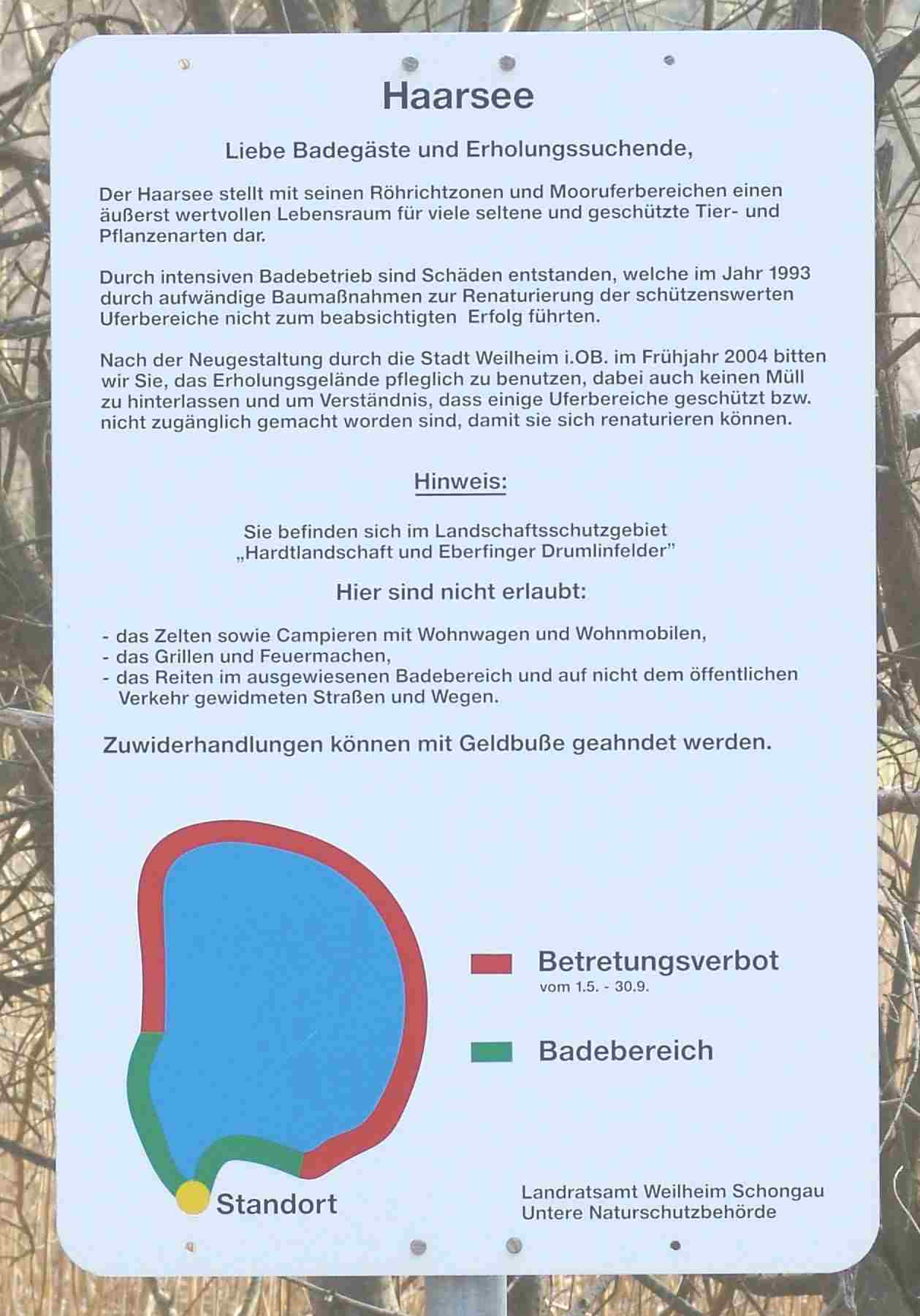
The lake is eutrophic , i.e. it contains a lot of phosphates, and the bathing water quality is in the highest rating. Sporadic contamination due to the agricultural use of the area can only occur after extremely heavy rain.
The Haarsee with its bank area is part of the landscape protection area Hardtlandschaft and Eberfinger Drumlinfelder . It is also located in the FFH area Eberfinger Drumlinfelder with Magnetsrieder Hardt and Bernrieder Filz , a type of protected area under European nature conservation legislation. The stiff sedge , the skullcap , the common yellow loosestrife , the true meadowsweet , the common purple loosestrife , the reed , the swamp blood-eye , the fever clover , the creeping willow and the rare water hemlock grow in the silting zones of the bank area .
The District Office as the lower nature conservation authority sees the Haarsee "with its reed beds and moor bank areas an extremely valuable habitat for many rare and protected animal and plant species" and therefore issued a ban on entering a large part of the bank area from May to September.
history
The name of the lake is derived from the field name Hardt , which is widespread in the area , which means “pasture in the forest”. A farm at the Haarsee is already occupied in 1349. The Schwaige Haarsee was one of six Schwaighöfen of the Polling monastery . The monastery used the lake, along with other artificial ponds in the vicinity, for fish farming. After secularization in 1803, the lake and the Schwaige came into private hands.
In 1908 the name of the lake was used in the new place name Hirschberg am Haarsee under which the family v. Hirschberg above the lake had Hirschberg Castle on the Haarsee built in neo-baroque style with elements of Art Nouveau. The lake was part of the private property of the von Hirschbergs and their successors. From then on it remained largely accessible to the public.
In the second half of the 20th century, the lake became popular with local residents as a bathing water. A simple lido with a kiosk and toilet facilities was operated. In the mid-1990s, the lido was closed, the buildings removed and the lake shore renatured. However, people continue to swim in the lake.
After the castle and lake had been sold to a private person by the Federal Property Office, the city of Weilheim agreed with the new owner in April 2004 that the lake should continue to be available to the general public free of charge as a bathing lake. In the course of the debate about the use of the castle, the city of Weilheim bought the Haarsee with 6.4 hectares of land in 2012 in order to secure it for the public.
Web links
- Haarsee at the Weilheim-Schongau district office
- Bathing water profile according to § 6 of the Bavarian Bathing Water Ordinance (PDF; 49 kB)
Individual evidence
- ^ Directory of the Bavarian lakes in the Bavarian State Office for Water Management from 1983
- ↑ http://www.haarsee.com/anlagen/anlage6.pdf
- ↑ http://www.haarsee.com/anlagen/anlage4.jpg
- ↑ a b Klaus Gast: The history of the "Schwaige Haarsee" - from 1908 "Hirschberg am Haarsee". In: Lech-Isar-Land 2011 . Local history yearbook, published by the Heimatverband Lech-Isar-Land eV, Weilheim i.Obb., 2011.
- ↑ www.merkur-online.de: Neighbors dispute at the Haarsee: petition against Gröber's plans
- ↑ Münchner Merkur: The Haarsee now belongs to the people of Weilheim , December 7, 2012