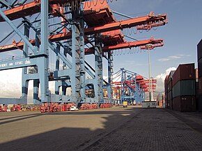
Beirut Harbor
| Beirut Harbor | |||
|---|---|---|---|
| Data | |||
| UN / LOCODE | LBBEY | ||
| Port type | seaport | ||
| website | www.portdebeyrouth.com | ||
| Geographic information | |||
| place | Beirut | ||
| Governorate | Beirut Governorate | ||
| Country | Lebanon | ||
| In the container port of Beirut | |||
| Coordinates | 33 ° 54 '26 " N , 35 ° 31' 31" E | ||
|
|||
The port of Beirut ( Arabic مرفأ بيروت, DMG Marfaʾ Bairūt ) is a seaport and district in the Lebanese capital Beirut . It is the largest port in the country. In an explosion on August 4, 2020 , it was so badly damaged that large parts can temporarily no longer be used.
history
Earliest evidence up to the Middle Ages
Beirut's ports played an important role in prehistoric and historical terms even before ancient times . At least since the 15th century BC. There is evidence of a port in the settlement. During the time of the Roman Empire, it developed into an important trading and economic center. During the Umayyad Caliphate in Damascus , the port of Beirut became the base of the first Arab fleet in the Mediterranean . For the crusaders and the Mameluks , the economic use was in the foreground.
The modern port until 1990
The modern port of Beirut was built in the 19th century during the time of the Ottoman Empire . On June 19, 1887, the Ottoman authorities issued a concession to found the "Compagnie du Port, des Quais et des Entrepôts de Beyrouth". In 1925 the operating company changed into French hands and in 1960 it was renamed the Lebanese "Compagnie de Gestion et d'Exploitation du Port de Beyrouth". Their concession expired in 1990.
Explosion disaster on August 4, 2020
On August 4, 2020, there was a fire in a warehouse. Shortly thereafter, a huge detonation shook the whole city. Houses within a radius of several kilometers were partially badly damaged by the explosion. Many people were injured or killed. The explosion tore a 40 m deep crater into the harbor. You and your shock wave could still be heard and felt in Cyprus several hundred kilometers away.
According to the Lebanese Interior Minister Mohammed Fahmi , 2,750 tons of ammonium nitrate were stored in the port , which could be the cause of the explosion. This substance is said to have been stored in a warehouse in the port for six years without precautionary measures.
Many buildings and facilities in the port were badly damaged or destroyed in the explosion. However, the port's container terminal, which was less affected, could be called again after about a week.
Location and connection
The port is located on St. George's Bay in the north of Beirut near the city center and in the east of the Mediterranean. Beirut, and with it the port, is connected to the Lebanese hinterland and the other cities of the country via many main roads.
Web links
Individual evidence
- ^ Port of Beirut: History . at www.portdebeyrouth.com, accessed December 29, 2015.
- ↑ Lebanon: Violent explosions shake Beirut. Der Spiegel, August 4, 2020, accessed on August 4, 2020 .
- ↑ Dozens dead and thousands injured in Beirut blast. BBC News, August 5, 2020, accessed August 4, 2020 .
- ↑ Mersiha Gadzo: Dozens Killed, Thousands wounded in Beirut explosion: Live. In: aljazeera.com , August 4, 2020, accessed on August 4, 2020.
- ↑ There are reports that up to 2,700 tonnes of ammonium nitrate being stored ... In: theguardian.com , August 4, 2020, accessed on August 4, 2020.
- ↑ Dozens of dead after explosions. In: orf.at , August 4, 2020, accessed on August 4, 2020.
- ↑ DER SPIEGEL: container terminal in Beirut back in operation after explosions - DER SPIEGEL - politics. Retrieved August 12, 2020 .

