
Hambantota (District)
Coordinates: 6 ° 7 ' N , 81 ° 7' E
| Hambantota District හම්බන්තොට දිස්ත්රික්කය அம்பாந்தோட்டை மாவட்டம் |
|
|---|---|

|
|
| Province : | Southern province |
| Administrative headquarters : | Hambantota |
| Area : | 2,609 km² |
| of which land area: | 2,496 km² |
| of which inland waters: | 113 km² |
| Residents : | 599903 |
| Population density : | 240 inhabitants / km² |
| Website : | District website |
The Hambantota district ( Sinhala හම්බන්තොට දිස්ත්රික්කය Hambantota distrikkaya ; Tamil அம்பாந்தோட்டை மாவட்டம் Ampāntōṭṭai māvaṭṭam ) is a district in the Southern Province in Sri Lanka . The main town is Hambantota .
geography
The Hambantota district is located in the south of the island on the coast and belongs to the southern province . Neighboring districts are Ratnapura and Moneragala in the north, Ampara in the northeast, the Indian Ocean in the south and Matara in the west.
Hambantota District covers an area of 2,609 square kilometers (of which 2,496 square kilometers are land and 113 square kilometers are inland water). This makes it the twelfth largest district in Sri Lanka in terms of area.
population
According to the 2012 census, the Hambantota district has 599,903 inhabitants. With 240 inhabitants per square kilometer, the population density is well below the Sri Lankan average (325 inhabitants per square kilometer). Of the residents, 294,736 (49.13%) were male and 305,167 (50.87%) were female. The population is very young. This is illustrated by a look at the age distribution.
| Age | 0–9 years | 10–19 years | 20-29 years | 30–39 years | 40-49 years | 50–59 years | 60–79 years | 80 years and more |
| number | 108,980 | 94,621 | 91,588 | 87,453 | 75,557 | 70,790 | 61,098 | 9,816 |
| proportion of | 18.17% | 15.77% | 15.27% | 14.58% | 12.59% | 11.80% | 10.18% | 1.64% |
District population by ethnic group
Almost the entire population are Sinhalese. Only in the Hambantota division do more than ten percent of the population belong to an ethnic minority. In all other divisions almost only Sinhalese live.
| year | Sinhalese 1 | Sri Lankan Tamils 2 | Indian Tamils 2 | Moors 3 | Burgher | Malays | Others 4 | Total | ||||||||
|---|---|---|---|---|---|---|---|---|---|---|---|---|---|---|---|---|
| No. | % | No. | % | No. | % | No. | % | No. | % | No. | % | No. | % | No. | % | |
| 1981 | 412.055 | 97.10% | 2,500 | 0.59% | 284 | 0.07% | 4,899 | 1.15% | 82 | 0.02% | 4,445 | 1.05% | 79 | 0.02% | 424.344 | 100.00% |
| 2001 | 510.965 | 97.07% | 1,869 | 0.36% | 424 | 0.08% | 5,646 | 1.07% | 88 | 0.02% | 7,255 | 1.37% | 167 | 0.03% | 526.414 | 100.00% |
| 2012 | 582,301 | 97.07% | 2,105 | 0.35% | 120 | 0.02% | 6,629 | 1.11% | 146 | 0.02% | 8,164 | 1.36% | 438 | 0.07% | 599.903 | 100.00% |
| Source: Sri Lanka censuses in 1981, 2001 and 2012 | ||||||||||||||||
1 lowland and Kandy Cinghalese together 2 Sri Lankan Tamils and Indian Tamil separately 3 only Sri Lankan Moors 4 thereof 2001 21 Sri Lanka Chetties and 3 Bharathas; including 17 Sri Lanka Cheties and 3 Bharathas in 2012
Population of the district by confession
Almost all Sinhalese residents Hambantotas hang the Buddhism , while the Moors and Malays all together to Islam profess. Only the fourth strongest religion is Hinduism , to which a narrow majority (around 55%) of the Indian and Sri Lankan Tamils belong. The Christian , the (approximately 2,000 persons) belonging to Burgher, a small minority of Cinghalese and a large minority of the Tamil (about 45%, or 1,000 people), although only a small minority religion. It is worth mentioning the strong growth of Protestants (mostly free churches; 1981–2012: + 872%) and Catholics (1981–2012: + 110%) nonetheless.
| year | Buddhists | Hindus | Muslims | Catholics | other Christs | Other | Total | |||||||
|---|---|---|---|---|---|---|---|---|---|---|---|---|---|---|
| No. | % | No. | % | No. | % | No. | % | No. | % | No. | % | No. | % | |
| 1981 | 411,919 | 97.07% | 2.174 | 0.51% | 9,408 | 2.22% | 542 | 0.13% | 174 | 0.04% | 127 | 0.03% | 424.344 | 100.00% |
| 2001 | 509.987 | 96.88% | 1,369 | 0.26% | 13,076 | 2.48% | 924 | 0.18% | 949 | 0.18% | 109 | 0.02% | 526.414 | 100.00% |
| 2012 | 580.344 | 96.74% | 1,222 | 0.20% | 15.204 | 2.53% | 1,139 | 0.19% | 1,692 | 0.28% | 302 | 0.05% | 599.903 | 100.00% |
| Source: Sri Lanka censuses in 1981, 2001 and 2012 | ||||||||||||||
Population development
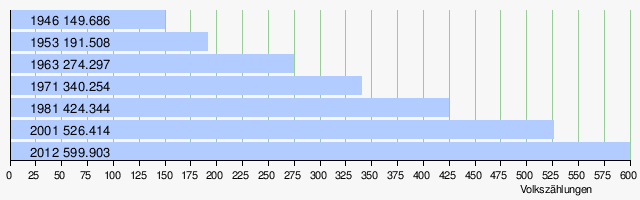
The population of Hambantota District has been growing steadily for decades. Between 2001 and 2012 (the last two census years) the increase was 73,489 people. This is a growth of 13.96%. Since 1946 the population has more than quadrupled (+ 301%).
The district was not a combat zone in the civil war. Therefore, only a small part of the migrants belong to the group affected by the civil war. In 2012, according to government statistics, there were only 1,616 refugees and returnees in the Hambantota district. These included 1,198 refugees from other areas of Sri Lanka and 418 people were resettled after being displaced.
Significant places
The only large towns in the district are Hambantota (2012: 23,236 inhabitants) and Tanggalla (2012: 8,473 inhabitants).
history
Because of its location on the southeast coast, the 2004 earthquake-triggered tsunami hit the coast with full force. At that time, according to official information, 2,739 people died in the Hambantota district. A further 56,135 became homeless and some injuries were caused.
Economy and Infrastructure
In mid-August 2010 a new port with four terminals was inaugurated in Hambantota . The project cost six billion US dollars and was built with financial support from China.
Local administration
The head of the district holds the title of District Secretary. The district is further divided into twelve divisions (under a Division Secretary). The cities and larger towns have their own administration (municipal parliament or council). There are 895 village administrations (Grama Niladharis) for the 2,446 villages in the entire district.
| Surname | main place | Residents 2012 |
Area in km² |
density | GN | Villages |
|---|---|---|---|---|---|---|
| Ambalantota | Malpattewa | 72,943 | 212 | 344 | 55 | 147 |
| Angunakolapelessa | Angunakolapelessa | 48,301 | 171 | 282 | 51 | 110 |
| Beliatta | Beliatta | 55.992 | 105 | 533 | 71 | 192 |
| Hambantota | Hambantota | 57,264 | 349 | 164 | 30th | 98 |
| Katuwana | Katuwana | 46,772 | 108 | 433 | 56 | 87 |
| Lunugamvehera | Lunugamvehera | 31,559 | 289 | 109 | 36 | 68 |
| Okewela | Okewela Junction | 19,018 | 44 | 432 | 27 | 58 |
| Suriyawewa | Suriyawewa | 43.102 | 192 | 224 | 21st | 56 |
| Tangalle | Tangalle | 72.507 | 149 | 487 | 72 | 182 |
| Thissamaharama | Wiravila | 68,606 | 773 | 89 | 44 | 154 |
| Walasmulla | Walasmulla | 42,274 | 103 | 410 | 53 | 97 |
| Weeraketiya | Weeraketiya | 41,565 | 114 | 365 | 60 | 89 |
| Hambantota District | Hambantota | 599.903 | 2,496 | 240 | 576 | 1,338 |
Web links
- Hambantota Tourist Information
- Hambantota an independent travelers' haven
- Chamber of Commerce of the district Hambantota (English)
Individual evidence
- ↑ Final result of the 2012 census
- ^ Map of the ethnic distribution after the 2012 census
- ↑ Data from Hambantota District after the 2012 census
- ^ Map of religious distribution after the 2012 census
- ↑ Data from Hambantota District after the 2012 census
- ↑ Migrants by reason of migration and district.
- ↑ Information on the effects of the 2004 tsunami ( Memento from May 18, 2007 in the Internet Archive )
- ↑ BBC News: Sri Lanka unveils new China-funded seaport in south
- ↑ Hambantota District Handbook 2011, Table 1.1
- ^ Map of the inhabitants by division
- ↑ Statistical Abstract of Sri Lanka 2013 ( Memento of the original from February 13, 2015 in the Internet Archive ) Info: The archive link has been inserted automatically and has not yet been checked. Please check the original and archive link according to the instructions and then remove this notice.
Ampara | Anuradhapura | Badulla | Batticaloa | Colombo | Bile | Gampaha | Hambantota | Jaffna | Kalutara | Kandy | Kegalle | Kilinochchi | Kurunegala | Mannar | Matale | Matara | Moneragala | Mullaitivu | Nuwara Eliya | Polonnaruwa | Puttalam | Ratnapura | Trincomalee | Vavuniya