Hammer (soldering)
|
hammer
Municipality Gross Koris
Coordinates: 52 ° 9 ′ 14 " N , 13 ° 44 ′ 35" E
|
|
|---|---|
| Postal code : | 15746 |
| Area code : | 033766 |
|
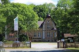
Head Forestry Hammer
|
|
Hammer is a residential area in the Löpten district of the Groß Köris community in the Dahme-Spreewald district in Brandenburg .
Geographical location
The residential area is northeast of the district and east of the community center. To the north is the district of Streganz of the municipality of Heidesee , to the west of the district of Hermsdorf of the municipality of Münchehofe , to the southwest of Löpten and to the west of the other residential area of Löpten-Süd. Federal highway 179 runs through the district in the eastern part in a north-south direction .
history
In 1700 there was a pitch furnace near the Hammer Vorwerk “with a little field of the Pichers”, which was called “Plan”. At that time, the area belonged to the Teupitz rule and thus to the Landsberg taverns . They did not allow the owners to keep more than 16 head of cattle and ten sheep. In 1717 the residential area came under the rule of King Wusterhausen . In 1743 a forester's house was built in the district not far from the Hammer dairy. This was also the first written mention of Hammer. The well known as "Schützen Hauß" was given by Friedrich Wilhelm I to his son August Wilhelm . Under his leadership, the Hammer Forest District was established in 1737 as part of the Princely Chamber.
In 1801 this forester's house was renamed again. In the meantime a sheep farm had been added. Four residents lived in the village , there were four fireplaces (= households). 1840 reported the statistics of the Oberförsterei Hammer and the sheep farm Klein Hammer; there were two apartment buildings. In 1858 the Königlich Hammersche Forst was established with the Groß Hammer colony, the Klein Hammer colony, the Buchholz forester's house and the Prieros forester's house. The landowner employed nine male and female servants and seven day laborers. There were two part-time farmers and one property, the royal forest with 35,814 acres . Another property was 194 acres, and two more totaled 38 acres. There were also four officers. In 1860 the chief forester existed with the pine seed kiln. It consisted of three residential and ten farm buildings. There was a chausseehaus, a sheep farm and a house in Groß Hammer, as well as three further residential buildings and four farm buildings following the head forester's house.
In 1900 there were eleven houses in Hammer. In 1929 the Hammersche Forst estate was dissolved. Some parts were incorporated into the community of Löpten, others to Klein Köris, Halbe and Gräfendorf. The remaining areas with parts from the manor district of Königs Wusterhausen Forest, Semmelei and Staakow became the manor district of Wusterhausener Heide. In 1932 the head forester's farm and the residential area existed as belonging to the municipality of Löpten.
Population development
| Population development in Hammer from 1772 to 1925 | ||||||||||||||||||
|---|---|---|---|---|---|---|---|---|---|---|---|---|---|---|---|---|---|---|
| year | 1772 | 1801 | 1840 | 1858 | 1925 | |||||||||||||
| Residents | 37 | 38 | 33 with small hammer | 23 and 15 (Groß Hammer) | 22nd | |||||||||||||
literature
- Lieselott Enders : Historical local lexicon for Brandenburg: Teltow (= Historical local lexicon for Brandenburg . Volume 4). Verlag Hermann Böhlaus successor, Weimar 1976.
