
Hartbach (Inn)
|
Hartbach (Reichersberger Bach) |
||
.jpg) Reichersberger Bach in the Reichersberg area near the Stifts-Gutshof |
||
| Data | ||
| location | Innviertel , Upper Austria | |
| River system | Danube | |
| Drain over | Inn → Danube → Black Sea | |
| Rejection Senftenbach (Iron Rail) | near St. Martin im Innkreis 48 ° 17 '14 " N , 13 ° 25' 57" E |
|
| Source height | at 380 m above sea level A. | |
| muzzle | in the Innauen bei Reichersberg Coordinates: 48 ° 20 '24 " N , 13 ° 21' 37" E 48 ° 20 '24 " N , 13 ° 21' 37" E |
|
| Mouth height | about 320 m above sea level A. | |
| Height difference | about 60 m | |
| Bottom slope | about 6.3 ‰ | |
| length | 9.5 km | |
| Catchment area | 9.723 km² | |
| Left tributaries | Sindhoring Bach | |
| Small towns | Reichersberg | |
| Communities | St. Martin iI, Reichersberg | |
| Hydraulic regulation of the High Middle Ages
Abiotic typing of Austrian rivers:
|
||
The Hartbach , also Reichersberger Bach , is a small tributary of the Inn in the west of the Upper Austrian district of Ried im Innkreis , near Reichersberg .
Run and landscape

Bach in the local area of Reichersberg near the Stifts-Gutshof
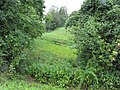
Bach in the local area of Reichersberg am Inn near the Stifts-Gutshof
_2.jpg)
_3.jpg)
The Hartbach rises in the municipality of St. Martin im Innkreis and flows northwest over Sindhöring and Hart (west of Ort im Innkreis ) and then northwest south of the Hartwald . Its lower course is the Reichersberger Bach through the market town of Reichersberg , where it disappears after about 9.5 km in the Innauen on the Lower Inn , which lies between the Egglfing-Obernberg power plant and the storage area of the Schärding-Neuhaus power plant .
The Sindhöringer Bach ( ⊙ ) is on the left .
History and construction
The lower reaches of the Hartbach, today's Reichersberger Bach, were already extensively diverted in the 11th century by the canons of the Reichersberg Monastery and relocated to about 5.5 km on the slope near the Meierhof in order to use its water to supply the monastery and its cultivation areas . The course was laid out in a strongly meandering manner early on - a contemporary source speaks of the advice "to dig the stream like the Saubär prunts" - and thus even corresponds to today's ideas of near-natural hydraulic engineering.
The origin of the stream is also highly restructured, sources can be found near the village of Karchham (near Aichingergut ⊙ ) and near Sankt Ulrich , a locality of the municipality of Senftenbach ( ⊙ ), but it gets most of its water east of it, where the Senftenbach , a tributary the Antiesen , is diverted so extensively that this is only marginal residual water to the Antiesen. From the weir called Iron Rail at the St. Martin train station, the water is fed to the Hartbach over a distance of around 2 km ( ⊙ ). This hydraulic engineering intervention also dates to the early High Middle Ages, also initiated by the Reichersberg Canons. Around 1085 work began on draining the wet meadows of the Hartbach – Senftenbach valley watershed in the area around today's Arco-Zinneberg Castle , and this diversion was also created to ensure the monastery was supplied with water. The Hartbach was also used to irrigate meadows and generate energy on the upper reaches, and there are also old artificial meanders here. It is also connected to the Antiesen, just below the Senftenbach estuary, by a ditch.
nature
The lower Inn is one of the most important nature reserves in Austria (nature reserve and European reserve, European reserve, Ramsar reserve and Important Bird Area), with the Hartbach estuary marking the southern border of the northern section of the European protected area (FFH and bird protection) Unterer Inn (eu01, AT3105000) , which is interrupted between Reichersberg and Obernberg .
literature
- Stefan Reifeltshammer: The Reichersberger Bach - An example of clever landscape valorisation . In: Innviertler Volkskundehaus (Ed.): The Bundschuh . Series of publications Museum Innviertler Volkskundehaus. tape 3 , 2000, pp. 13-18 .
- Stefan Reifeltshammer: The Reichersberger Bach - An example of clever landscape valorisation . In: Landscape planning contributions from the Innviertel . Vienna 2001, p. 102–114 (supplement: vegetation tables and maps).
References and comments
- ↑ a b Total length from the Senftenbach diversion named in Clemens Gumpinger, Simonetta Siligato: Defense register of the Antiesen and their feeders . In: Maria Hofbauer, Office of Upper Austria. State government (Ed.): Water protection report . tape 37 , November 2007, Senftenbach , p. 54 ( land-oberoesterreich.gv.at [PDF]> Topics> Environment> Water> Surface waters).
- ^ Office of Upper Austria. State government, Directorate Environment and Water Management, Department Surface Water Management / DORIS → Water & Geology → GEO Juhu (i) → Detailed catchment areas : Hartbach - from the Sindhöringer Bach to the confluence with the Inn 6.2925; Hartbach - up to the supply line from Senftenbach 3.43
- ↑ according to the Federal Ministry of Agriculture, Forestry, Environmental Protection and Water Management (ed.): EU Water Framework Directive 2000/60 / EG - Austrian report on the IST . Inventory. Vienna 2000. Data in: Max H. Fink, Otto Moog, Reinhard Wimmer: Flowing water natural spaces in Austria . In: Umweltbundesamt (Ed.): Monographs . (M-128). tape 128 . Vienna 2000, ISBN 3-85457-558-0 , 4.2.2 Innviertler- and Hausruckviertler Hügelland , p. 67 ( Umweltbundesamt.at [PDF]).
- ↑ Lit. Reifeltshammer 2000, cit. n. Michael Hohla: "Flora von Reichersberg" Reuss 1819 then and now - (not) a comparison! In: Conservation Department - Upper Austria (ed.): ECO * L . No. 24/2 , p. 17–23 ( flora-deutschlands.de [PDF; accessed on October 4, 2010] site pdf p. 5f, with fig. 17: excerpt from the unfortunately undated map by Maurer… ).
- ↑ namely while walking; Quotation from Reifeltshammer 2000, quoted in n. Hohla 2002
- ↑ a b Lit. Reifeltshammer 2000, cited. n. Gumpinger, Siligato: Defense register of the Antiesen . S. 54 , col. 2 .
- ↑ Gumpinger, Siligato: military land registry . (Internal number of the structure in the cadastre: transverse structure no. 3–17).
- ↑ Lower Inn European Protected Area. In: Genisys detailed view. State of Upper Austria, accessed on June 23, 2010 .
- ↑ FFH and bird sanctuary Unterer Inn. (No longer available online.) In: land-oberoesterreich.gv.at> Natura 2000 protected areas. Province of Upper Austria, archived from the original on October 6, 2014 ; Retrieved June 23, 2010 . Info: The archive link was inserted automatically and has not yet been checked. Please check the original and archive link according to the instructions and then remove this notice.