
Place in the Innkreis
|
Place in the Innkreis
|
||
|---|---|---|
| coat of arms | Austria map | |
 |
|
|
| Basic data | ||
| Country: | Austria | |
| State : | Upper Austria | |
| Political District : | Ried im Innkreis | |
| License plate : | RI | |
| Surface: | 11.49 km² | |
| Coordinates : | 48 ° 19 ' N , 13 ° 26' E | |
| Height : | 360 m above sea level A. | |
| Residents : | 1,286 (January 1, 2020) | |
| Population density : | 112 inhabitants per km² | |
| Postal code : | 4974 | |
| Area code : | 07751 | |
| Community code : | 4 12 20 | |
| NUTS region | AT311 | |
| UN / LOCODE | AT OIN | |
| Address of the municipal administration: |
Place in the Innkreis 81 | |
| Website: | ||
| politics | ||
| Mayor : | Walter Reinthaler ( FPÖ ) | |
|
Municipal Council : (2015) (19 members) |
||
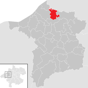
| Location of Ort im Innkreis in the Ried im Innkreis district | ||
  |
||
| Source: Municipal data from Statistics Austria | ||

Ort im Innkreis is a municipality in Upper Austria in the district of Ried im Innkreis in the Innviertel with 1286 inhabitants (as of January 1, 2020). The community is located in the judicial district of Ried im Innkreis .
geography
Ort im Innkreis is 360 m above sea level in the Innviertel. The extension is 4.5 km from north to south and 5.4 km from west to east. The total area is 11.3 km². 15% of the area is forested, 74.3% of the area is used for agriculture.
Districts
The municipality includes the following localities (population in brackets as of January 1, 2020):
- Aichberg (82) including Bamersberg, Niederaschbach and Schneglberg
- Aigen (36)
- Bischelsdorf (123)
- Chamber (0)
- Cellars (18)
- Place in the Innkreis (770) including Au
- Easter after (214)
- Stött (43)
coat of arms
Official description of the municipal coat of arms: In gold, a green oak branch growing out of the base of the shield, which is covered by a blue bar with silver diamonds in it so that three leaves are visible above, two leaves below and two red acorns above. The municipality colors are green-white-green.
history
Since the founding of the Duchy of Bavaria, the place was Bavarian until 1779 and came to Austria after the Treaty of Teschen with the Innviertel (then 'Innbaiern'). Briefly Bavarian again during the Napoleonic Wars , since 1814 it has finally belonged to Upper Austria.
After the annexation of Austria to the German Reich on March 13, 1938, the place belonged to the Gau Oberdonau . After 1945 the restoration of Upper Austria took place.
Population development
In 1991 the community had 1,202 inhabitants. Despite the positive birth balance (+53), the population fell to 1,181 inhabitants in 2001 due to emigration. In the next decade, the migration balance fell to −5, so that the population rose to 1,221 with an almost unchanged birth balance.
politics
Walter Reinthaler from the FPÖ has been mayor since 2009.
Culture and sights

- Regular events
traffic
Street
The Ort im Innkreis exit from the Innkreisautobahn (A8) is only about one kilometer west of the town center, but it is already in the Reichersberg municipality.
Public transport
From Monday to Friday, Ort im Innkreis is connected to the district capital by the Postbus line 840 ( Ried im Innkreis - Aurolzmünster - Easterach - Antiesenhofen ) of the OÖVV .
bicycle
A short section of the Antiesen cycle path (R23) runs through Ort im Innkreis .
Public facilities
There is a kindergarten, a primary school, a multi-purpose hall and a sewage treatment plant in the community.
Web links
- Place in the Innkreis
- Further information about the municipality of Ort im Innkreis on the geographic information system of the federal state of Upper Austria .
Individual evidence
- ↑ Statistics Austria: Population on January 1st, 2020 by locality (area status on January 1st, 2020) , ( CSV )
- ^ State of Upper Austria, history and geography, coat of arms. Retrieved April 10, 2019 .
- ^ Statistics Austria, A look at the municipality of Ort im Innkreis, population development. Retrieved April 10, 2019 .
- ^ Province of Upper Austria, results of the 2015 elections. Accessed April 10, 2019 .
- ↑ DORIS Atlas 4.0. Retrieved February 3, 2019 .
- ↑ Timetable for line 840 of the Upper Austrian Transport Association. Retrieved February 3, 2019 .
- ↑ Antiesen cycle path R23. Retrieved February 3, 2019 .

Andrichsfurt | Antiesenhofen | Aurolzmünster | Eberschwang | Eitzing | Geiersberg | Geinberg | Belts | Hohenzell | Kirchdorf am Inn | Kirchheim im Innkreis | Lamb rights | Lohnsburg am Kobernaußerwald | Mehrnbach | Mettmach | Mörschwang | Mühlheim am Inn | Neuhofen im Innkreis | Obernberg am Inn | Place in the Innkreis | Pattigham | Peterskirchen | Pramet | Reichersberg | Ried im Innkreis | St. Georgen near Obernberg am Inn | St. Marienkirchen am Hausruck | St. Martin im Innkreis | Schildorn | Senftenbach | Taiskirchen im Innkreis | Tumeltsham | Utzenaich | Waldzell | Weilbach | Wippenham