Waldzell
|
Waldzell
|
||
|---|---|---|
| coat of arms | Austria map | |
|
|
||
| Basic data | ||
| Country: | Austria | |
| State : | Upper Austria | |
| Political District : | Ried im Innkreis | |
| License plate : | RI | |
| Surface: | 40.25 km² | |
| Coordinates : | 48 ° 8 ' N , 13 ° 26' E | |
| Height : | 522 m above sea level A. | |
| Residents : | 2,217 (January 1, 2020) | |
| Population density : | 55 inhabitants per km² | |
| Postal code : | 4924 | |
| Area code : | 07754 | |
| Community code : | 4 12 34 | |
| NUTS region | AT311 | |
| Address of the municipal administration: |
Hofmark 1 4924 Waldzell, Germany |
|
| Website: | ||
| politics | ||
| Mayor : | Johann Jöchtl ( SPÖ ) | |
|
Municipal Council : (2015) (25 members) |
||
| Location of Waldzell in the Ried im Innkreis district | ||
| Source: Municipal data from Statistics Austria | ||
Waldzell is a municipality in Upper Austria in the district of Ried im Innkreis in the Innviertel with 2217 inhabitants (as of January 1, 2020). The community is located in the judicial district of Ried im Innkreis .
geography
Waldzell lies at 522 m above sea level in the Innviertel. The extension is 11.1 km from north to south and 7.9 km from west to east. The total area is 40.2 km². 48.8% of the area is forested, 45.5% of the area is used for agriculture.
The municipality includes the following localities (population in brackets as of January 1, 2020):
- Bach (72)
- Baumgarten (31)
- Besendorf (49)
- Bleckenwegen (44) including Mayrhof
- Brackenberg (80)
- Brandstatt (8)
- Brast (18)
- Breitwies (58)
- Dundeck (20)
- Noble helmet (12)
- Federation (28)
- Gitthof (55)
- Hack lock (77) including Au
- Hartlberg (64)
- Höschmuehl (26)
- Servants (53)
- Coal corner (71)
- Lerz (16)
- Maireck (51)
- Neffenedt (17)
- Nussbaum am Kobernaußer Walde (157) including Haberpoint
- Reith (32)
- Harvester (43)
- Schratteneck (155) including Ertlmoos, Schreimoos and Wies
- Schwendt (36)
- Strass (168)
- Waldzell (695) including Steitzing
- Weissenbrunn (21)
- Wirglau (36)
- Wirmling (24) including Mooseck
The Schwemmbach (Riedlbach) rises in the municipality of Waldzell, on the Steiglberg, and flows into the Mattig in the municipality of Uttendorf .
The Waldzeller Ache also flows through the municipal area.
coat of arms
Official description of the municipal coat of arms:
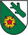
- Divided diagonally ; above in silver a slanting, green, cut branch , below in green a golden, heraldic rose with a red clump and red sepals.
The community colors are red-white-green
history
From the founding of the Duchy of Bavaria , Waldzell was Bavarian until 1779 and came to Austria after the Treaty of Teschen and the Innviertel (then Innbaiern ) . During the Napoleonic Wars briefly royal Bavarian again , since 1814 it has finally belonged to the crown land of Austria above the Enns .
After the annexation of Austria to the German Reich on March 13, 1938, the place belonged to the Gau Oberdonau . After 1945 the restoration of Upper Austria took place.
politics
Mayor is Johann Jöchtl (SPÖ).
Population development
In 1991 the municipality had 1,969 inhabitants according to the census, in 2001 it had 2,096 inhabitants.
Culture and sights
- See also: List of listed objects in Waldzell
- The Waldzell parish church is a Gothic building with ribbed vaults, which has been given a baroque style, especially on the outside with stucco ribbons. The high altar was built in 1683 using the statues of St. Mary, St. Barbara and St. Katharina built by Thomas Schwanthaler from the former Gothic winged altar .
Personalities
- Franz-Paul Kröll sen (* 1818) surgeon
- Franz-Paul Kröll jun (* 1846) surgeon
- Andreas Goldberger (* 1972), ski jumper
- Ferdinand Marschall (1924–2006), football referee
- Jakob Mayr (1894–1971), politician and school director
Individual evidence
- ^ Province of Upper Austria - Geographical data of the municipality of Waldzell .
- ↑ Statistics Austria: Population on January 1st, 2020 by locality (area status on January 1st, 2020) , ( CSV )
Web links
- More information about the community of Waldzell on the geo-information system of the federal state of Upper Austria .


