
Helpfau-Uttendorf
|
market community Helpfau-Uttendorf
|
||
|---|---|---|
| coat of arms | Austria map | |
 |
|
|
| Basic data | ||
| Country: | Austria | |
| State : | Upper Austria | |
| Political District : | Braunau am Inn | |
| License plate : | BR | |
| Main town : | Uttendorf | |
| Surface: | 26.34 km² | |
| Coordinates : | 48 ° 9 ' N , 13 ° 7' E | |
| Height : | 419 m above sea level A. | |
| Residents : | 3,707 (January 1, 2020) | |
| Population density : | 141 inhabitants per km² | |
| Postal code : | 5261 | |
| Area code : | 07724 | |
| Community code : | 4 04 13 | |
| NUTS region | AT311 | |
| Address of the municipal administration: |
Uttendorf 11 5261 Helpfau-Uttendorf |
|
| Website: | ||
| politics | ||
| Mayor : | Josef Johann Leimer ( ÖVP ) | |
|
Municipal Council : (2015) (25 members) |
||
| Location of Helpfau-Uttendorf in the Braunau am Inn district | ||
  |
||
 Uttendorf Castle and Market 1779 |
||
| Source: Municipal data from Statistics Austria | ||

Helpfau-Uttendorf is a market town in Upper Austria in the Braunau am Inn district in the Innviertel with 3707 inhabitants (as of January 1, 2020). The responsible judicial district is the judicial district Braunau am Inn .
geography
Helpfau-Uttendorf lies at an altitude of 419 m in the Innviertel. The extension is 6.1 km from north to south and 7.9 km from west to east. The total area is 26.5 km². 25.7% of the area is forested, 62.6% of the area is used for agriculture.
Community structure
The municipality includes the following 21 localities (population in brackets as of January 1, 2020):
|
|
|
The community consists of the cadastral communities Helpfau, Kager, St. Florian and Uttendorf.
Neighboring communities
| Burgkirchen | Wall churches | Moosbach |
.svg)
|
||
| Pischelsdorf am Engelbach | Bowl | Maria Schmolln |
coat of arms
Official description of the municipal coat of arms : In blue on a golden three-mountain, a silver, three-sided, hexagonal tower, the ground floor with five battlements and a black open arched gate with golden, opened gate leaves; the cuboid upper floor with three battlements and two black open windows. The community colors are blue-yellow.
history
The Mattig Valley was already settled in the Stone Age, around 7,000 years ago. Accordingly, many historical finds have been made. The best known is the golden choker from a princely barrow. It is a grave attachment from the Hallstatt period . The necklace was recovered in 1885 on behalf of the Upper Austrian State Museum and can be viewed in Linz today. Unfortunately, many of these finds also fell victim to looters. Just a few decades ago, remnants of Roman roads could still be seen in the Lohnau district.
In 789 Helpfau was first mentioned in a document as "Helpfo". Uttendorf was first mentioned in 1120. Market rights were granted in 1481. Until 1780 the place was Bavarian and after the peace of Teschen with the Innviertel (then Innbaiern ) came to Austria.
In 1779 - after the Innviertel was incorporated into Austria - Uttendorf is described as follows:
A princely market and its own nursing dishes. In the older times belonged to the Trostburg nursing court, where it is also counted in the Wening's topography T.II p.53. Located on the Mattig River between Mauerkirchen and Mattigkofen. There is news there that in 1692, on July 17th, the water of the otherwise small Mattig ran up so much after a downpour and long rain that one could sail through the market in ships like on a ship-wide water. By the way, this area is very famous for its game and good fishing. In the year 1441 and 50 years later this market was put into the ashes twice, where all the documents and other original letters of the market were destroyed during the last fire. In the church, the holy apostles Peter and Paul are venerated as patron saints. About four hundred years ago Bernhard von Grambs owned Uttendorf as a lordship. After the extinction of this generation is the house of Bavaria same home like .
Briefly Bavarian again during the Napoleonic Wars , it has finally belonged to Upper Austria since 1816 ( Treaty of Munich ). The market, which was destroyed by fire in 1835, was rebuilt by 1841. Until 1850 today's Helpfau-Uttendorf consisted of the four tax communities Kager, Helpfau, St. Florian and Uttendorf. On May 11th of this year the local council decided to found the double community Helpfau-Uttendorf. After Austria was annexed to the German Reich on March 13, 1938, the place belonged to the Reichsgau Oberdonau . After 1945 the restoration of Upper Austria took place.
politics
- Mayor is Josef Johann Leimer from the ÖVP .
- Local council: The distribution of seats in the local council is ÖVP 16 seats, SPÖ 3 seats and FPÖ 6 seats.
Population development
In the statistics of Austria data, a steady population growth has been evident since 1971. In 1971 there were 2,620 inhabitants, the number rose to 3,442 by 2016. This corresponds to a growth of almost 24% over a period of 45 years.
Culture and sights
In total there are four churches in Helpfau-Uttendorf.
- Parish church of Helpfau
- Market church Uttendorf
- The Uttendorf Castle Chapel above the Kalvarienberg in the center of Uttendorf. It is the only surviving piece of a castle that was located on Kalvarienberg and the symbol of the market town.
- The Filialkirche St. Florian bei Helpfau is a Gothic church with a remarkable baroque style. Around 1885 the church tower was expanded with Raimund Jeblinger . In front of the building is a military cemetery of the 6th Stalingrad Army of the Second World War .

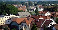
Uttendorf's landmark: Schlossberg with castle church

Filial church of St Florian

View from the Schlossberg in north-east direction

View from the Schlossberg in east direction
View from the Schlossberg in south-east direction

Market square Helpfau-Uttendorf

Cadastral parish of St. Florian


- Uttendorf Castle : The Prince's Castle Uttendorf was a castle that was once located on the Kalvarienberg above the market. In the 18th century it was demolished due to its ailing condition. The stones were then used to build the St. Josef Hospital in Braunau am Inn. The only remaining part of the palace is the former palace chapel on the Schlossberg. Today it is the landmark of Uttendorf. The area where the building was located is now wooded. A few remains of the foundation walls can still be seen. The princely castle of Uttendorf is anchored in the municipal coat of arms.
- Market place: The market place is the historical core of Uttendorf. Here you will find inns, cafes, retail stores, banks and administrative facilities. In 1835 the market was completely destroyed by a devastating fire except for three buildings. This was rebuilt in its current form by 1841.
- Mattigtal Hedge Labyrinth of Human Rights (MHM): On a private initiative, a hedge labyrinth was planted in the village of Reichsdorf from 2005 onwards, starting from an orchard meadow. With a diameter of 64 m and a hedge length of around 1000 linear meters, it should be the largest hedge labyrinth in Austria and open to the public by 2014 at the latest. The motto of the labyrinth - ... and should meet each other in a spirit of brotherhood! - is taken from the human rights declaration of 1948. A sculpture in the center of the labyrinth will act as a memorial. The sculptor Stefan Esterbauer has presented a draft for the "Mattigtal Band of Brotherhood".
- Geological organs : In the district "Steinbruch" there are two easily accessible, close together places with partly very large geological organs.
Regular events
- FF masked ball: takes place every year on Carnival Saturday
- Josefimarkt: The Josefimarkt is held annually, one week before Josef's name day. It falls into the Kirtag category, although many companies also present their products.
- Rural Youth Ball: The Rural Youth Ball takes place annually on January 5th.
- Stock car races: The annual state championship in stock car races takes place in July.
traffic
Train and bus
Helpfau-Uttendorf is connected to the Mattigtalbahn . Many professionals and students use the train to z. B. to commute to Salzburg or Braunau am Inn.
The Postbus lines 320 and 330 enable both trips to other places, such as Braunau or Straßwalchen , as well as getting around within the market town.
Street
The community is crossed by the B 147 (Braunauer Straße) . In the industrial area, the B 142 (Mauerkirchener Straße) branches off towards Altheim . The Mattighofen bypass, which will lead through the community of Uttendorf, is in the planning stage. Above all, it should give companies in the region an advantage.
Established businesses
In the last few decades, an industrial area of considerable size has emerged in Helpfau-Uttendorf. There are u. a. Forwarding agencies, sawmills, waste material collection center , door and Gate manufacturers, printers, coaters and construction companies. Since there are only a few free plots left there, the so-called industrial area south is being built on the border to Schalchen between the Mattig river and the B 147 . This area is still largely undeveloped. But there are also businesses outside these zones that are scattered throughout the municipality. These include, for example, a brick factory in the Reith district and a brewery in the center of Uttendorf, which produces various types of beer and lemonade.
- Uttendorfer businessmen: The Uttendorfer businessmen are an association of tradespeople and innkeepers in Helpfau-Uttendorf. Together they lead u. a. Promotions to stimulate retail through.
Public facilities
One of the noteworthy public institutions is the parish library, which was revived a few years ago. Here it is possible to borrow books and games for a small fee. The so-called parent-child center, or EKIZ for short, provides leisure activities tailored to children, especially in summer. Evenings with lectures and parenting tips are often organized for parents.
societies
There are over 40 clubs in Uttendorf. Here are some of them:
- The "rural youth" (organizes a ball on January 5th every year)
- The "Schützenverein" (annual school graduation fire)
- Mattigtaler Perchten
- Tennis club
- Football club (SV Raiffeisen Uttendorf)
- Asphalt / curling
- The "MIC Uttendorf" stock car association (organizes the annual stock car race in Uttendorf)
- Musikverein Harmonie Uttendorf
Fire brigades
- Voluntary fire brigade (FF) Uttendorf
- FF free lift
- FF Reith
literature
- Topography or brief description of the district in the Bavarian region which the most lucid ore house in Austria took possession of by virtue of the convention concluded with the Electoral Palatinate of Teschen , Vienna 1779.
Web links
- Official homepage of the market town of Helpfau-Uttendorf
- Further information about the gold choker
- The restoration of the Uttendorf gold ring (PDF; 2.3 MB)
- 40413 - Helpfau-Uttendorf. Community data, Statistics Austria .
- Further information about the municipality of Helpfau-Uttendorf can be found on the geo-information system of the federal state of Upper Austria .
Individual evidence
- ^ Province of Upper Austria - Geographical data of the municipality of Helpfau-Uttendorf .
- ↑ Statistics Austria: Population on January 1st, 2020 by locality (area status on January 1st, 2020) , ( CSV )
- ↑ Grafitto et al. History. http://www.helpfau-uttendorf.at/ , accessed on April 23, 2017 .
- ↑ A look at the community of Helpfau-Uttendorf <40413>. (PDF) Statistics Austria, accessed on April 23, 2017 .
- ↑ [1]

Altheim | Aspach | Auerbach | Braunau am Inn | Burgkirchen | Eggelsberg | Feldkirchen | Franking | Geretsberg | Gilgenberg | Haigermoos | Handenberg | Helpfau-Uttendorf | Hochburg-Ach | Höhnhart | Jeging | Kirchberg | Lengau | Punch | Maria Schmolln | Mattighofen | Wall churches | Mining | Moosbach | Moosdorf | Munderfing | Neukirchen | Easter rental | Palting | Perwang | Pfaffstätt | Pischelsdorf | Polling | Rossbach | St. Georgen | St. Johann | St. Pantaleon | St. Peter | St. Radegund | St. Veit | Bowl | Schwand | Tarsdorf | Treubach | Oversize | Weng