St. Pantaleon (Upper Austria)
|
St. Pantaleon
|
||
|---|---|---|
| coat of arms | Austria map | |
|
|
||
| Basic data | ||
| Country: | Austria | |
| State : | Upper Austria | |
| Political District : | Braunau am Inn | |
| License plate : | BR | |
| Main town : | Saint Pantaleon | |
| Surface: | 18.32 km² | |
| Coordinates : | 48 ° 0 ' N , 12 ° 54' E | |
| Height : | 436 m above sea level A. | |
| Residents : | 3,162 (January 1, 2020) | |
| Population density : | 173 inhabitants per km² | |
| Postal code : | 5120 | |
| Area code : | 06277 | |
| Community code : | 4 04 37 | |
| NUTS region | AT311 | |
| Address of the municipal administration: |
Sankt Pantaleon 54 5120 St. Pantaleon |
|
| Website: | ||
| politics | ||
| Mayor : | Valentin David ( ÖVP ) | |
|
Municipal Council : (2015) (25 members) |
||
| Location of St. Pantaleon in the Braunau am Inn district | ||
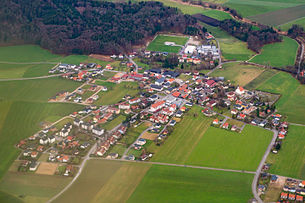
 Aerial view of St. Pantaleon |
||
| Source: Municipal data from Statistics Austria | ||
St. Pantaleon (also Sankt Pantaleon ; in the local dialect Pontigo ) is a municipality in the Upper Austrian Innviertel ( district of Braunau am Inn ), with 3162 inhabitants (as of January 1, 2020).
geography
St. Pantaleon is 436 m above sea level. A. in the Upper Innviertel , directly on the Salzach , on the other side of this is Bavaria .
St. Pantaleon borders the Austrian state of Salzburg to the south
The extension is 7.5 km from north to south and 5.7 km from west to east. The total area is 18.32 km². 23.6% of the area is forested, 63.7% of the area is used for agriculture.
The small Höllerersee is located in a wooded depression in the municipality .
Neighboring communities
|
Salzach |
Haiger moss |
Franking |

|
∗ |
|
|
Salzach
|
Sankt Georgen bei Salzburg ( District Salzburg-Umg. , SBG ) |
Community structure
The municipal area includes the cadastral communities St. Pantaleon , Steinwag and Wildshut .
The localities of the municipality are (in brackets the number of inhabitants as of January 1st 2020):
- Hollersbach (26) (also in Ostermiething )
- Kirchberg (204)
- Laubenbach (18)
- Loidersdorf (109)
- Muhlach (16)
- Pirach (58)
- Reith (206)
- Riedersbach (846)
- Roidham (22)
- Saint Pantaleon (949)
- Seeleiten (80)
- Stone wagon (31)
- Stockham (91)
- Trimmelkam (371)
- Wild hat (135)
There are also localities with their own names that are assigned to one or two localities such as Eiferding , Esterloh , Söllham , Pichling , as well as Kirchberg Siedlung , Riedersbach Siedlung and the Vorderberger Siedlung .
Counting districts are Riedersbach for the northern part of the municipality with Trimmelkam, and St.Pantaleon - Wildshut for the south and east.
The responsible judicial district is the judicial district Mattighofen , until 2004 the municipality belonged to the judicial district Wildshut .
history
Since the founding of the Duchy of Bavaria , the place was Bavarian until 1779 and came to Austria after the Treaty of Teschen with the Innviertel (then Innbaiern ) .
During the Napoleonic Wars briefly Bavarian again , St. Pantaleon has belonged to Austria on the Enns since 1814 . Since 1918 the place belongs to the federal state of Upper Austria .

After Austria was annexed to the National Socialist German Reich on March 13, 1938, the place belonged to the Gau Oberdonau . During the Nazi era , the National Socialists set up the St. Pantaleon-Weyer labor education and gypsy detention camp on what was then the municipality in Weyer (today part of the municipality of Haigermoos ) , which initially operated as a labor education camp until January 1941 and then until the end of 1941 was continued as a gypsy detention camp.
In 2000 , the Weyer / Innviertel camp was created on the Moosach , a small tributary of the Salzach , and a memorial was erected there. The prisoners of the former National Socialist prison camp in Weyer were used as slave labor to regulate the Moosach. A bridge that leads over the Moosach in the immediate vicinity of the first camp and connects St. Pantaleon with the Salzburg municipality of St. Georgen was declared a bridge of remembrance by the mayor of Sankt Pantaleon and the mayor of the neighboring municipality in 2009 .
Population development
In 1991 the community had 3,108 inhabitants according to the census, in 2001 there were 3062 inhabitants. From 2001 to 2011 the migration balance remained negative, but it was offset by the positive birth balance, so that the population rose again to 3,093. In 2018 the population fell to 3,085.
politics
Distribution of seats since the municipal council election 2015:
- 6 mandates of the Social Democratic Party of Austria (SPÖ)
- 11 mandates of the Austrian People's Party (ÖVP)
- 4 mandates for the Freedom Party of Austria (FPÖ)
- 4 mandates open community list
- mayor
- until 2009 Herbert Huber (SPÖ)
- since 2009 Valentin David (ÖVP)
coat of arms
The official description of the municipal coat of arms reads:
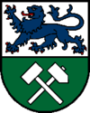
- Shared ; above in silver a blue, red armored and tongued, walking lion , below in green diagonally crossed a silver hammer and a silver mallet. The municipality colors are blue-white-green.
- The lion indicates that the municipality was part of Bavaria for a long time. The miners' symbols Hammer and Schlegel stand for lignite mining.
Culture and sights
Both parish churches are under monument protection .
societies
- Trimmelkam miner's chapel
- Trimmelkam miner's choir
- Trimmelkam Miners Club
- St. Pantaleon music band
- Child friends Riedersbach
- Country youth St. Pantaleon
- UPS St. Pantaleon
- Mining friends St. Pantaleon
traffic
There are five stations on the Bürmoos – Ostermiething railway line in the municipality . This is operated by Salzburg AG and is integrated into the Salzburg S-Bahn as line S11 . The stops are approached every hour, sometimes every half hour.
sport and freetime
The community is a member of the Seelentium tourism region .
The Höllerersee is an excursion destination and is used both in summer and in winter for leisure purposes (swimming, fishing, ice skating). It is one of several small lakes in the surrounding area, which gave the tourist region Seelentium its name.
The "Ibmer Moor Radweg" (Ibmer Moor Radweg), a cycle path from the nearby Ibmer Moor that leads through the St. Pantaleon village of Riedersbach to Hochburg-Ach , runs through the municipality of St. Pantaleon .
Personalities
- Franz Höfer (* 1980), triathlete, lives in St. Pantaleon
- Karl Kinzl (1878–1949), farmer and politician, member of the community committee
- Ludwig Laher (* 1955), writer, lives in St. Pantaleon
- Lukas Perman (* 1980), singer, grew up as the son of local doctor Ulrich Permanschlager in St. Pantaleon
- Karlheinz Schönswetter (1941–2006), artist, was director of the St. Pantaleon secondary school from 1981 to 1989
- Reinhard Todt (* 1949), politician, born in St. Pantaleon
literature
- Ludwig Laher: Heart flesh degeneration . Novel. Unabridged paperback edition. Haymon Verlag, Innsbruck 2009, ISBN 978-3-85218-808-9 .
- Ludwig Laher: The gypsy detention camp Weyer-St. Pantaleon. Coincidental center of the Nazi policy of segregation in the Gau Oberdonau. In: Oberösterreichisches Landesarchiv (OÖLA) (ed.), Florian Freund (edit.): Upper Austria and the "Gypsies". Politics against a minority in the 19th and 20th centuries. OÖLA, Linz 2010, ISBN 978-3-900313-97-5 ( online ).
- Andreas Maislinger : Supplement to a local chronicle. "Labor education camp" and "Gypsy collective camp" Weyer. In: Austria in history and literature. With geography , issue 3–4 / 1988, ISSN 0029-8743 .
Web links
- Community website
- Tourism website , on oberoesterreich.at
- 40437 - St. Pantaleon (Upper Austria). Community data, Statistics Austria .
- Entry on St. Pantaleon in the Austria Forum (in the AEIOU Austria Lexicon )
- More information about the municipality of St. Pantaleon (Upper Austria) on the geo-information system of the federal state of Upper Austria .
- Map in the Digital Upper Austrian Room Information System ( DORIS )
- Saint Pantaleon . In: Salzburger Nachrichten : Salzburgwiki .
- Street map St. Pantaleon , on stpantaleon.at (PDF; 9.6 MB)
Individual evidence
- ↑ The official spelling is specified or shown in the list of the municipalities of the Upper Austrian provincial government on the Internet and on Statistics Austria: A look at the municipality
- ↑ Statistics Austria: Population on January 1st, 2020 by locality (area status on January 1st, 2020) , ( CSV )
- ↑ Ludwig Laher : Herzfleischentartung . Novel. Unabridged paperback edition. Haymon Verlag, Innsbruck 2009, ISBN 978-3-85218-808-9 .
- ↑ Ludwig Laher: The gypsy detention camp Weyer-St. Pantaleon. Coincidental center of the Nazi policy of segregation in the Gau Oberdonau. In: Oberösterreichisches Landesarchiv (OÖLA) (ed.), Florian Freund (edit.): Upper Austria and the "Gypsies". Politics against a minority in the 19th and 20th centuries. OÖLA, Linz 2010, ISBN 978-3-900313-97-5 ( online ( memento of the original from January 13, 2009 in the Internet Archive ) Info: The archive link has been inserted automatically and has not yet been checked. Please check the original and archive link according to the instructions and then remove this notice. ).
- ^ Statistics Austria, A look at the community of St. Pantaleon, population development. Retrieved April 6, 2019 .
- ^ State of Upper Austria, history and geography, coat of arms. Retrieved April 6, 2019 .


