
Eggelsberg
|
market community Eggelsberg
|
||
|---|---|---|
| coat of arms | Austria map | |
 |
|
|
| Basic data | ||
| Country: | Austria | |
| State : | Upper Austria | |
| Political District : | Braunau am Inn | |
| License plate : | BR | |
| Surface: | 24.12 km² | |
| Coordinates : | 48 ° 5 ' N , 13 ° 0' E | |
| Height : | 531 m above sea level A. | |
| Residents : | 2,449 (January 1, 2020) | |
| Population density : | 102 inhabitants per km² | |
| Postal code : | 5142 | |
| Area code : | 07748 | |
| Community code : | 4 04 06 | |
| NUTS region | AT311 | |
| UN / LOCODE | AT EGB | |
| Address of the municipal administration: |
Marktplatz 13 5142 Eggelsberg |
|
| Website: | ||
| politics | ||
| Mayor : | Christian Michael Kager ( ÖVP ) | |
|
Municipal Council : (2015) (25 members) |
||
| Location of Eggelsberg in the Braunau am Inn district | ||
  |
||
| Source: Municipal data from Statistics Austria | ||

Eggelsberg is a market town in Upper Austria in the Braunau am Inn district in the Innviertel with 2,449 inhabitants (as of January 1, 2020). The responsible judicial district is the judicial district Mattighofen , until 2004 the municipality belonged to the judicial district Wildshut .
geography
Eggelsberg lies at an altitude of 531 m in the Innviertel. The extension is 7 km from north to south and 6.9 km from west to east. The total area is 24.2 km². 20.7% of the area is forested, 69.0% of the area is used for agriculture. The Ibmer Moor with its nature trail is the largest moor area in Austria. The Heratinger See (Ibmer See) in the southwest is the main attraction for tourism, along with the nature trail on the moor.
Community structure
The municipality includes the following 28 localities (population in brackets as of January 1, 2020):
- Arnstetten (40)
- Autmannsdorf (62)
- Beckenberg (44)
- Bergstetten (78)
- Eggelsberg (876)
- Großschäding (31)
- Gundertshausen (218)
- Haselreith (39)
- Hehenberg (19)
- Heimhausen (93)
- Heated (14)
- Hötzenau (2)
- Ibm (331)
- Kleinschäding (48)
- Meindlsberg (5)
- Bad (12)
- Oberhaslach (10)
- Oberhaunsberg (20)
- Pippmannsberg (53)
- Eggelsberg district (72)
- Gundertshausen District (114)
- Heimhausen district (57)
- Trametshausen (64)
- Underground (6)
- Unterhaunsberg (39)
- Wannersdorf (73)
- Weilbuch (13)
- Vineyard (16)
The community consists of the cadastral communities Eggelsberg, Gundertshausen, Haimhausen, Haselreith and Ibm.
The neighboring communities of Eggelsberg are:
| Gilgenberg am Weilhart | Handenberg | St. Georgen am Fillmannsbach |
| Geretsberg |
.svg)
|
Feldkirchen near Mattighofen |
| Franking | Moosdorf |
history
Eggelsberg was Bavarian from the founding of the Duchy of Bavaria until 1779 and came to Austria after the Treaty of Teschen with the Innviertel (then Innbaiern ) . During the Napoleonic Wars briefly Bavarian again , the place has been part of Upper Austria since 1814. After Austria was annexed to the German Reich on March 13, 1938, the place belonged to the "Gau Oberdonau". After 1945 the restoration of Upper Austria took place.
On April 6, 1988, a jet aircraft of the Federal Armed Forces of the type Saab 105Ö (Lfz GJ-20-S.Nr.:105420) crashed in Eggelsberg. The pilot Lieutenant Colonel Otto Laimgruber (45) was killed.
- Population development
In 1991 the community had 1,906 inhabitants according to the census, in 2001 it had 2,112 inhabitants. This strong growth is due to a positive migration balance and a very positive birth balance . Both balances remained positive, so that the population increased to 2,276 in 2011, to reach a new high of 2,365 in 2018.
politics
Mayor is Christian Michael Kager (ÖVP).
coat of arms
Blazon of the market town's coat of arms: two golden, diagonally crossed sceptres in blue. The market town colors are blue and yellow.
Culture and sights
- Eggelsberg parish church : built 1420–1436, Gothic, two-aisled, interior baroque, tower from 1754, former pilgrimage church
- Schnaitl Brewery: with brewery inn and brewery tours
- Moor hiking trail on Ibmer Moor
- Ibm Castle

Heratinger See
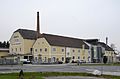
Schnaitl Brewery

Chapel in Ibm


tourism
Eggelsberg has been forming an association with a number of other communities in the Upper Innviertel since 2011 and is part of the Seelentium tourist region . The focus is on day and weekend guests, the main attractions are Ibmer Moor , Heratinger See and Gundertshausen with the Schnaitl private brewery and various exhibitions in Haus Rauhberg and at Zenz Holzbau.
Tourist offers:
- Guided moor hikes (orchid hike, with the moor guard in Ibmer Moor, guided tours for children, etc.)
- Barefoot hikes around the Ibmer-Heratingersee
- Guided bike tours (several bike routes cross the municipality)
- Guided tours through the Schnaitl brewery
Established businesses
- Bernecker & Rainer , control systems, automation technology
- Schnaitl Brewery
Personalities
- Oliver Pum (* 1993), composer and music producer
- Moritz Moser (* 1992), soccer player
- Doris Fürk-Hochradl (* 1981), writer and religious educator
Web links
- Website of the market town of Eggelsberg
- 40406 - Eggelsberg. Community data, Statistics Austria .
- Further information about the municipality of Eggelsberg can be found on the geographic information system of the federal state of Upper Austria .
Individual evidence
- ↑ Statistics Austria: Population on January 1st, 2020 by locality (area status on January 1st, 2020) , ( CSV )
- ↑ Statistics Austria, A look at the community Eggelsberg, population development. Retrieved April 6, 2019 .
- ^ Province of Upper Austria, 2015 election. Retrieved April 6, 2019 .
- ^ State of Upper Austria, history and geography, coat of arms. Retrieved April 6, 2019 .

Altheim | Aspach | Auerbach | Braunau am Inn | Burgkirchen | Eggelsberg | Feldkirchen | Franking | Geretsberg | Gilgenberg | Haigermoos | Handenberg | Helpfau-Uttendorf | Hochburg-Ach | Höhnhart | Jeging | Kirchberg | Lengau | Punch | Maria Schmolln | Mattighofen | Wall churches | Mining | Moosbach | Moosdorf | Munderfing | Neukirchen | Easter rental | Palting | Perwang | Pfaffstätt | Pischelsdorf | Polling | Rossbach | St. Georgen | St. Johann | St. Pantaleon | St. Peter | St. Radegund | St. Veit | Bowl | Schwand | Tarsdorf | Treubach | Oversize | Weng