Jeging
|
Jeging
|
||
|---|---|---|
| coat of arms | Austria map | |
|
|
||
| Basic data | ||
| Country: | Austria | |
| State : | Upper Austria | |
| Political District : | Braunau am Inn | |
| License plate : | BR | |
| Surface: | 6.58 km² | |
| Coordinates : | 48 ° 3 ' N , 13 ° 9' E | |
| Height : | 486 m above sea level A. | |
| Residents : | 705 (January 1, 2020) | |
| Population density : | 107 inhabitants per km² | |
| Postal code : | 5225 | |
| Area code : | 07744 | |
| Community code : | 4 04 16 | |
| NUTS region | AT311 | |
| UN / LOCODE | AT JEG | |
| Address of the municipal administration: |
Jeging 1 5225 Jeging |
|
| Website: | ||
| politics | ||
| Mayor : | Christoph Weitgasser ( ÖVP ) | |
|
Municipal Council : (2015) (13 members) |
||
| Location of Jeging in the Braunau am Inn district | ||
 Municipal Office |
||
| Source: Municipal data from Statistics Austria | ||
Jeging is a municipality in the Braunau am Inn district in the Innviertel in Upper Austria with 705 inhabitants (as of January 1, 2020). It covers an area of 6.55 km². The competent judicial district is the judicial district Mattighofen .
Community structure
The municipality includes the following nine localities (population in brackets as of January 1, 2020):
- But (198)
- Bernroid (19)
- Commercial area (since 2015) (3)
- Hochhalting (51)
- Jeging (273)
- Oberedt (61)
- Pfaffing (5)
- Schweiber (82)
- Unteredt (13)
The municipality consists of the cadastral municipality Jeging.
coat of arms
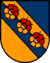
Official description: A diagonal right-hand bar divided by gold and blue, covered with three heraldic roses with six petals, red above, gold below; blue above, gold below. Community colors: blue-yellow-blue.
history
Jeging belonged to Bavaria for centuries . The von Jeging men can be traced back to 753. The last, Heinrich von Jeging, who remained without male descendants, withdrew to the Benedictine Abbey of Michaelbeuern in 1392 and gave his property as a benefice . The former seat of the gentlemen von Jeging passed into municipal property through an exchange in 1968 and is used as the municipality's official building. Through the Peace of Teschen in 1779, Jeging and the entire Innviertel (then Innbaiern) became part of Austria.
education
Jeging runs a two-class elementary school and an all-day kindergarten. The Volksbildungswerk Jeging association is dedicated to adult education.
politics
The municipal council with 13 seats has the following distribution as of 2015: ÖVP: 5, SPÖ: 4, FPÖ: 2, Jeginger Independent List 2.
- mayor
- until 2014 Herbert Eder (SPÖ)
- 2014–2015 Ursula Lindenhofer (SPÖ)
- since 2015 Christoph Weitgasser (ÖVP)
Culture and sights
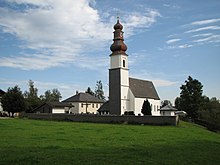
- Catholic parish church Jeging hl. Stephan
Web links
- Community website
- 40416 - Jeging. Community data, Statistics Austria .
- Further information about the municipality of Jeging can be found on the geographic information system of the federal state of Upper Austria .
Individual evidence
- ↑ Statistics Austria: Population on January 1st, 2020 by locality (area status on January 1st, 2020) , ( CSV )
- ^ State of Upper Austria, history and geography, coat of arms. Retrieved April 6, 2019 .
- ^ Province of Upper Austria, results of the elections, Jeging. Retrieved April 6, 2019 .


