Andrichsfurt
|
Andrichsfurt
|
||
|---|---|---|
| coat of arms | Austria map | |
|
|
||
| Basic data | ||
| Country: | Austria | |
| State : | Upper Austria | |
| Political District : | Ried im Innkreis | |
| License plate : | RI | |
| Surface: | 12.35 km² | |
| Coordinates : | 48 ° 16 ' N , 13 ° 31' E | |
| Height : | 440 m above sea level A. | |
| Residents : | 781 (January 1, 2020) | |
| Postal code : | 4754 | |
| Area code : | 07750 | |
| Community code : | 4 12 01 | |
| NUTS region | AT311 | |
| UN / LOCODE | AT RCH | |
| Address of the municipal administration: |
Andrichsfurt 40 4754 Andrichsfurt |
|
| Website: | ||
| politics | ||
| Mayor : | Johann Brandstetter ( ÖVP ) | |
|
Municipal Council : (2015) (13 members) |
||
| Location of Andrichsfurt in the Ried im Innkreis district | ||
| Source: Municipal data from Statistics Austria | ||
Andrichsfurt is a municipality in Upper Austria in the district of Ried im Innkreis in the Innviertel with 781 inhabitants (as of January 1, 2020). The community is located in the judicial district of Ried im Innkreis .
geography
Andrichsfurt is between 400 and 500 m above sea level in the Innviertel. The extension is 5.1 km from north to south and 5.7 km from west to east. The total area is 12.3 km², 9.8% of the area is forested, 80.5% of the area is used for agriculture.
Community structure
The municipality includes the following localities (population in brackets as of January 1, 2020):
- Albertsedt (11)
- Andrichsfurt (239)
- Baumgartling (42)
- Furt (84) including Erdmannsdorf
- Gehnbach (38)
- Irger (12)
- Staples (53)
- Moosedt (5)
- Pesenreit (2)
- Poetting (186)
- Raschhof (19)
- Stone size (38)
- Stelzham (8)
- Walchshausen (16)
- Weilhart (28) including Mauzedt
The community consists of three cadastral communities :
- Andrichsfurth (380.86 ha)
- Frauenhub (316.36 ha)
- Pötting (538.04 ha)
Neighboring communities
| Utzenaich | ||
| Aurolzmünster |

|
Taiskirchen in the Innkreis |
| Tumeltsham | Peterskirchen |
history
Since the founding of the Duchy of Bavaria , the place was Bavarian until 1779 and came to Austria after the Treaty of Teschen with the Innviertel (then Innbaiern ) . During the Napoleonic Wars briefly Bavarian again , since 1816 it has finally belonged to Austria ob der Enns .
After the annexation of Austria to the German Reich on March 13, 1938, the place belonged to the Gau Oberdonau . In 1945 Upper Austria was restored.
Population development

Culture and sights

- Andrichsfurt Parish Church : A Gothic church from the second half of the 15th century with a single-nave , three-bay nave and a two-bay choir . On the south side, a three-bay aisle and porches on Tuscan columns were added in the middle of the 17th century. Most of the furnishings date from the 18th century.
politics
The municipal council has a total of 13 members. With the municipal council and mayoral elections in Upper Austria in 2015 , the municipal council has the following distribution: 9 ÖVP and 4 FPÖ.
- mayor
- since 2002 Johann Brandstetter (ÖVP)
coat of arms
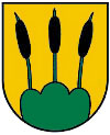
Official description of the municipal coat of arms : "In gold on a green three-mountain, three green reed stalks with black cobs." The municipality colors are yellow-green.
The municipal coat of arms awarded in 1974 is based on the family coat of arms of the Murhaimer, an old Bavarian family that was also based around Andrichsfurt. At the same time it symbolizes the triple mount the three located around the village hills Stelzerhöhe, Andrich Furter mountain and Saxberger mountain and the reed formerly vast marshland in the valley of Osternach .
Web links
- Community website
- Map in the Digital Upper Austrian Room Information System ( DORIS )
- 41201 - Andrichsfurt. Community data, Statistics Austria .
- Further information about the municipality of Andrichsfurt can be found on the geographic information system of the federal state of Upper Austria .
Individual evidence
- ^ Province of Upper Austria - Geographical data of the municipality Andrichsfurt
- ↑ Statistics Austria: Population on January 1st, 2020 by locality (area status on January 1st, 2020) , ( CSV )
- ^ Herbert Erich Baumert: The coats of arms of the cities, markets and communities of Upper Austria (4th supplement 1973–1976) . In: Oberösterreichische Heimatblätter, Heft 1/2, 1977, p. 8 ( online (PDF) in the forum OoeGeschichte.at)


