Ravsted Sogn
|
Ravsted Sogn ( German Rapstedt ) |
||||
|
||||
| Basic data | ||||
|---|---|---|---|---|
| State : |
|
|||
| Region : | Syddanmark | |||
|
Municipality (since 2007) : |
Aabenraa | |||
| Coordinates : | 55 ° 0 ′ N , 9 ° 8 ′ E | |||
|
Population : (2020) |
964 | |||
| Postal code : | 6372 Bylderup-Bov | |||
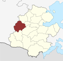
 Location of the Ravsted Sogn in the Aabenraa municipality |
||||
Ravsted Sogn (German Rapstedt , formerly also written Rab- or Raebstedt in both languages) is a parish ( Danish : Sogn ) in North Schleswig , Denmark . Until 1970 it belonged to Harde Slogs Herred in Tønder Amt , then to Tinglev Kommune in Sønderjyllands Amt . Since 2007 it has belonged to the newly formed Aabenraa municipality , Region Syddanmark . On January 1, 2020, 964 people lived in the community, 440 of them in Ravsted .
Municipal area
Neighboring municipalities are Bedsted Sogn and Hellevad Sogn in the north, Hjordkær Sogn and Bjolderup Sogn in the east, Bylderup Sogn in the south and Øster Højst Sogn in the west .
Ravsted Kirke
The whitewashed late Romanesque village church was probably built around 1250. The tower is from the 15th century. The stepped gable of the late medieval armory dates from 1743. The excellent late Gothic winged altar from approx. 1475 was restored in 1985.
Individual evidence
- ↑ a b Statistics Banks -> Befolkning og valg -> KM1: Befolkningen January 1st, April 1st, July 1st and October 1st, so og folkekirkemedlemsskab (Danish)
- ↑ Statistics banks -> Befolkning og valg -> BY1: Folketal January 1st efter byområde, alder og køn (Danish)
Web links
- ravsted.dk Local web portal (Danish)
- Ravsted local history Local history of Ravsted (Danish)

