Holbøl Sogn
|
Holbøl Sogn ( German Holebüll ) |
||||
|
||||
| Basic data | ||||
|---|---|---|---|---|
| State : |
|
|||
| Region : | Syddanmark | |||
|
Municipality (since 2007) : |
Aabenraa | |||
| Coordinates : | 54 ° 54 ' N , 9 ° 27' E | |||
|
Population : (2020) |
1,467 | |||
| Area : | 50.87 km² | |||
| Population density : | 29 inhabitants per km² | |||
| Postal code : | 6340 Kruså | |||
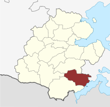
 Location of Holbøl Sogn in Aabenraa municipality |
||||
Holbøl Sogn ( German: Holebüll ) is a parish ( Danish : Sogn ) in Northern Schleswig in southern Denmark . Until 1970 she belonged to Harde Lundtoft Herred in what was then Aabenraa-Sønderborg Amt, then to Bov Kommune in what was then Sønderjyllands Amt , which was merged into the "new" Aabenraa commune in the Syddanmark region as part of the local government reform on January 1, 2007 .
Municipal area
The landscape of the parish, which extends from east to west up to 12 km, is very diverse. The Geest begins to the west of the church village , while the eastern part is hilly. The community is heavily forested towards the Flensburg Fjord . A specialty are the two ox islands in the fjord, which also belong to this parish.
The parish of Holbøl has an area of 50.87 km², on January 1, 2020 1,467 inhabitants lived, of which 428 live in the village itself. The parish includes the following settlements, which formed separate parishes in the Prussian period from 1867 to 1920:
- Gejlå (German: Gehlau )
- Øster Gejl (German: Ostergeil )
- Vilsbæk (German: Wilsbek )
- Holbøl (German: Holebüll )
- Hokkerup (German: Hockerup )
- Kelstrupskov (German: Kelstrup wood )
- Hønsnap (German: Hoenschnap )
The municipality of Hønsnap had previously belonged to the Flensburg office and, contrary to the principle that the borders should be as compatible as possible, remained with the Flensburg district in 1867 .
history
In the Middle Ages, the area of Holbøl belonged to the Lundtoftharde, which was initially administered from Søgård Castle (Eng .: Seegaard ) in the municipality of Kliplev (Eng. Klipleff ). Already at the end of the 14th century the castle became a noble estate, which also included part of the Holbøl parish. The remains of the Lundtoftharde were despite lesser distance from the sovereign castles in Flensburg, Aabenraa (dt. Apenrade ) and Sønderborg (dt. Sonderburgstraße ) the Official Tonder assumed. Only Hønsnap retained the traditional connection with Flensburg over the centuries.
In 1850 the Lundtoftharde was subordinated to the Aabenraa Office , in 1853 all aristocratic estates were also subordinated to it. Since Hønsnap stayed with the Flensburg office, the municipality remained inconsistent.
The referendum in Schleswig in 1920 on the constitutional status brought a Danish majority of 598 to 279 votes. From June 15, 1920, Holbøl was Danish and from then on was less than 10 kilometers from the new border to Germany.
In 1970 Holbøl became part of Bov Municipality , which in 2007 became part of Aabenraa Municipality.
Attractions
- Romanesque church in Holebüll, frescoes, free-standing wooden tower ( stack of bells )
- Ox Islands, the larger one can be reached by ferry
- Beaches on the Flensburg Fjord, e.g. B. at Sønderhav (German: Süderhaff )
Web links
- Entry in the Sogne portal (Danish)

