
Haverbeeke
| Haverbeeke | ||
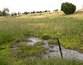
 The stream in Haverbeeker Holz |
||
| Data | ||
| location | Lueneburg Heath Nature Reserve , Heidekreis District , Lower Saxony , Germany | |
| River system | Weser | |
| Drain over | Wümme → Lesum → Weser → North Sea | |
| source | southwest of the Wilseder Berg 53 ° 9 ′ 39 ″ N , 9 ° 55 ′ 15 ″ E |
|
| muzzle | below the Wümmeberg in the Wümme coordinates: 53 ° 8 '43 " N , 9 ° 53' 6" E 53 ° 8 '43 " N , 9 ° 53' 6" E
|
|
| length | approx. 4 km | |
| Communities | Bispingen | |
| Spring waters of the Wümme and the Lesum | ||
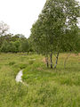
 The meandering brook below the Wümmeberg |
||
The Haverbeeke is an approximately 4 km long source stream of the Wümme in the Heidekreis district in Lower Saxony . The brook rises about 2 kilometers southwest of the Wilseder mountain . It mainly flows in a north-south and east-west direction through heather, forest and meadow areas in the Lüneburg Heath nature reserve . In its course the brook crosses Niederhaverbeck . About 1.5 kilometers west of the town in the Wümme valley, it flows into the Wümme below the Wümmeberg.
Since the Haverbeeke watered at the confluence and also longer than the Wümme that Haverbeeke is gewässerkundlich not a tributary , but the real source of the river Wümme and thus the Lesum .
Description and stream course
The Bach name is composed of the terms Haver and Beeke (Bach), where Haver could be derived from oats , among other things . The brook gave its name to the Bispinger district Haverbeck with the villages Nieder- and Oberhaverbeck. Before the renaturation carried out in 1990 by the Nature Conservation Park Association , the stream was straightened. Since then it has been a near-natural heathland again, which is constantly redesigning its bed. In the course of the stream, oxbow lakes and swamp areas, vegetation typical of the location has now established itself.
The Haverbeek wood lines the stream as a narrow piece of forest. The brook has been dammed into smaller ponds in five places. Since the last pond, the extinguishing water pond in Niederhaverbeck, interrupted the fish migration and had other undesirable ecological effects, the course of the stream parallel to the pond was restored.
Especially in the lower valley area, the stream flows over water-permeable sand (uppermost part of the Wümme- Sanders from the penultimate Ice Age ) and therefore falls dry in periods with little precipitation ( stream shrinkage ). However, the water continues to move at shallow depths on impermeable boulder clay and emerges again in deeper spring areas.
To the west of Niederhaverbeck, the Naturschutzpark Verein created two hiking trails for wheelchair users as nature trails in the Haverbeeke valley . In the Wümmetal a hiking trail crosses the stream over a wooden walkway.
Source area
Flood plain

Wooden footbridge over the stream

Haverbeeke before the union with the dry lying Wümme (behind)


