Hebach
|
Hebach Hebachsbach |
||
|
The Hebach in Radheim |
||
| Data | ||
| Water code | DE : 24759232 | |
| location |
Rhine-Main lowlands
|
|
| River system | Rhine | |
| Drain over | Welzbach → Main → Rhine → North Sea | |
| source | at the Talhof south of Schaafheim 49 ° 53 '58 " N , 9 ° 0' 10" E |
|
| Source height | 210 m above sea level NHN | |
| muzzle | in Radheim in den Welzbach Coordinates: 49 ° 53 '17 " N , 9 ° 0' 56" E 49 ° 53 '17 " N , 9 ° 0' 56" E |
|
| Mouth height | 165 m above sea level NHN | |
| Height difference | 45 m | |
| Bottom slope | 28 ‰ | |
| length | 1.6 km | |
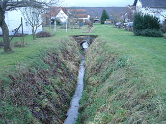
The Hebach , also called Hebachsbach , is a left tributary of the Welzbach in Bachgau in Hesse .
geography
course
The Hebach rises at a height of about 210 m above sea level. NHN am Talhof south of Schaafheim .
It flows in a southerly direction and finally flows into Radheim at an altitude of 165 m above sea level. NHN from the left into the Welzbach . The street Am Hebach in Radheim was named after the Hebach .
Its 1.6 km long run ends 45 meters below its source, so it has an average bed gradient of 28 ‰.
Catchment area
The catchment area of the Hebach lies in the Reinheim hill country and is drained to the North Sea via the Welzbach, the Main and the Rhine .
It borders
- in the northeast to that of the Dürrbach , a tributary of the Welzbach
- and in the west to that of the Länderbach , the right upper reaches of the Ohlebach , which drains over the Gersprenz into the Main.
The catchment area is characterized by arable land, in the estuary area the location of Radheim dominates.
Web links
Individual evidence
- ↑ a b c Google Earth
- ↑ The Hebachsbach in waters mapping service of the Hessian Ministry for the Environment, Climate Change, Agriculture and Consumer Protection
- ↑ Water map service of the Hessian Ministry for the Environment, Climate Protection, Agriculture and Consumer Protection ( information )
